
dirganews.com – The American highway system is often characterized as a utilitarian network designed for the efficient displacement of goods and people. Yet, within this vast grid, U.S. Route 66 stands as a distinct cultural and historical anomaly. Established in 1926, the highway served as the primary artery for the westward expansion of the United States, bridging the industrial Midwest with the Pacific Coast. To undertake a Road Trip Adventure on Route 66 today is not merely an act of tourism; it is a complex engagement with the layers of 20th-century economic shifts, architectural evolution, and the eventual obsolescence of localized commerce in the wake of the Interstate Highway System.
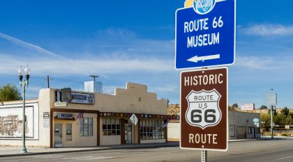
The road’s trajectory spanning approximately 2,448 miles from Chicago, Illinois, to Santa Monica, California mirrors the nation’s mid-century narrative. It was the conduit for the “Okies” fleeing the Dust Bowl in the 1930s, a vital supply line for the war effort in the 1940s, and the primary stage for the burgeoning middle-class vacation culture of the 1950s. Today, the route exists in a fragmented state. Having been officially decommissioned in 1985, it is no longer a continuous thoroughfare on modern maps. Instead, it is a patchwork of “Historic” designations, state-maintained secondary roads, business loops, and decaying bypasses that require specific navigational literacy to traverse successfully.
Modern engagement with the route often oscillates between nostalgia-driven preservation and the stark reality of rural decline. This article examines the structural, historical, and practical dimensions of the journey, treating the road as a living museum of American infrastructure that demands both patience and intellectual curiosity.
Understanding “Road Trip Adventure on Route 66”
www.toursofdistinction.net
The phrase Road Trip Adventure on Route 66 is frequently reduced to a simplistic checklist of landmarks, such as the Gateway Arch, the Blue Whale of Catoosa, or the Santa Monica Pier. This reductionist view ignores the systemic reality of the road. In contemporary terms, the “adventure” is actually a complex logistical operation involving the synchronization of vintage infrastructure with modern vehicle capabilities and the limitations of digital navigation.
A common misunderstanding is that the road is a static entity. In reality, Route 66 is a series of “alignments.” Because the road was constantly being paved, widened, or rerouted between 1926 and 1985, a traveler might choose between a 1930s dirt path and a 1950s four-lane divided highway, both of which occupy different physical spaces but carry the same historical name. The oversimplification risk here is significant: travelers who do not account for these shifts often find themselves on dead ends or redirected onto I-40, missing the very cultural context they sought.
From a multi-perspective view, the road represents different things to different stakeholders:
-
The Historian: A record of the transition from an agrarian to an automotive society.
-
The Urbanist: A case study in how the bypass culture of the Federal Aid Highway Act of 1956 decimated small-town economies.
-
The Logistics Specialist: A challenging route that demands attention to fuel ranges, seasonal weather patterns, and varying road surfaces.
Navigating this environment requires an analytical mindset. It is not a passive experience like driving on an interstate; it is an active engagement with a changing landscape that requires constant course correction and an appreciation for the “friction” of travel.
Deep Contextual Background
The genesis of Route 66 was rooted in the “Good Roads Movement” of the early 20th century. Unlike the Lincoln Highway, which prioritized a straight line across the continent, Route 66 was designed with a diagonal trajectory. This was a deliberate economic strategy spearheaded by Cyrus Avery of Oklahoma and John Woodruff of Missouri. Their goal was to link hundreds of rural communities to the larger markets of Chicago and Los Angeles, effectively “hooking up” the rural Midwest to the national economy.
As the Great Depression took hold, the road became a symbol of survival. John Steinbeck famously labeled it the “Mother Road” in The Grapes of Wrath, highlighting its role as a conduit for desperate migration. However, the post-World War II era shifted the narrative toward upward mobility. The rise of the automobile as a symbol of personal freedom transformed the road into a corridor of innovation in roadside architecture. This period saw the birth of mimetic buildings (structures shaped like tepees, dogs, or coffee pots), neon-drenched signage, and the development of the “motel,” a contraction of “motor hotel” designed specifically for the transient driver.
The decline began in 1956 with the signing of the Federal Aid Highway Act. President Dwight D. Eisenhower, influenced by his observations of the German Autobahn during the war, championed a system of high-speed, limited-access highways. These new Interstates (I-55, I-44, I-40, I-15, and I-10) largely superseded Route 66. Towns that were bypassed often saw their main streets vanish into economic obsolescence within a decade. The current revival of the road is a grassroots phenomenon, driven by state-level historic associations and international tourism, creating a fragmented but resilient ecosystem that requires careful navigation.
Conceptual Frameworks and Mental Models
To effectively plan a Road Trip Adventure on Route 66, one must employ specific mental models that differ from standard, high-speed travel planning.
1. The Alignment Layering Model
Travelers should view the road not as a single line, but as a stack of historical layers. At any given point in Oklahoma or New Mexico, there may be three different versions of Route 66 existing parallel to one another: the 1920s unpaved “ribbon” road, the 1940s two-lane blacktop, and the post-1960s frontage road. The traveler must decide which layer to prioritize based on vehicle capability and interest in historical accuracy versus comfort.
2. The Preservation Paradox
This model posits that the more “authentic” a location feels, the more fragile its infrastructure likely is. Many of the most iconic stops are maintained by aging owners or small non-profits. Reliance on these points of interest (POIs) involves a high degree of variability in operating hours and service quality. The paradox is that seeking the “real” Route 66 necessitates embracing its inherent unreliability.
3. The Kinetic Energy vs. Geographic Depth Trade-off
This framework weighs the desire to “complete” the 2,400 miles against the desire to experience individual communities.
-
High Kinetic Energy: A 5–7 day transit. This focuses on major landmarks but forces the driver onto the Interstate for 80% of the journey to maintain pace.
-
High Geographic Depth: A 14–21 day exploration. This prioritizes the original pavement and local interaction, necessitating a significantly slower average speed (often 35–45 mph).
Key Regional Categories and Variations
The journey is segmented into distinct geographic and cultural zones, each presenting unique challenges.
| Region | Primary Landscape | Infrastructure Condition | Cultural Focus |
| The Rust Belt (IL/MO) | Urban industrial to rolling hills | High maintenance; urban congestion | Mid-century diners; bridge architecture |
| The Ozarks (MO/KS) | Dense forests; tight curves | Narrow; winding; technical driving | Mining history; quirky roadside stops |
| The Plains (OK/TX) | Flat; agricultural; high wind | Wide; straight; varying quality | Native American history; oil boom legacy |
| The High Desert (NM/AZ) | Arid; high elevation | Long stretches of isolation | Adobe architecture; neon preservation |
| The Mojave (AZ/CA) | Extreme desert; mountain passes | High heat stress, remote, rugged | Ghost towns; harsh terrain navigation |
| The Coast (CA) | Suburban sprawl to the Pacific | Heavy traffic; modern urban | The “End of the Trail” symbolism |
Decision Logic for Route Selection
When approaching a segment like the Black Mountains in Arizona, a traveler must decide between the Sitgreaves Pass (the original Route 66) and the Interstate-40 bypass. The decision logic involves three variables:
-
Vehicle Capacity: Can the cooling system and brakes handle 12% grades and hairpin turns without guardrails?
-
Time Delta: The pass takes approximately 90 minutes; the interstate takes 20.
-
Visual ROI: The pass offers some of the most dramatic vistas on the entire route, while the interstate offers zero.
Detailed Real-World Scenarios
The Chicago Departure (The Urban Gridlock)
A traveler attempting to follow the original path through the Chicago suburbs faces dozens of stoplights and heavy commercial traffic.
-
Decision Point: Follow the historic signs through every municipality or bypass the first 30 miles via I-55 to reach the rural transition in Joliet.
-
Failure Mode: Losing 4 hours of daylight in the first 50 miles, leading to an unplanned night in an area lacking historic lodging.
The Texas Panhandle (The Weather Variable)
Crossing the plains involves dealing with high crosswinds and potential supercell thunderstorms.
-
Second-Order Effect: High winds significantly reduce fuel economy in high-profile vehicles like RVs or camper vans. Travelers often forget that the “adventure” includes managing the mechanical stress of the environment.
-
Constraint: If wind speeds exceed 40 mph, staying on the two-lane historic road becomes dangerous due to the narrow lanes and lack of shoulders.
The Ghost Town Exploration (The Safety Constraint)
Places like Glenrio (on the TX/NM border) or Two Guns (Arizona) offer ruins of the original road.
-
Risk: Structural instability of abandoned buildings and the presence of desert wildlife.
-
Constraint: Total lack of cellular service means a mechanical failure here requires self-rescue or waiting for another infrequent traveler. The “adventure” here shifts from sightseeing to survival management.
Planning, Cost, and Resource Dynamics
travel.home.sndimg.com
A Road Trip Adventure on Route 66 is an exercise in variable budgeting. Costs are not distributed evenly across the eight states.
Direct and Indirect Costs
-
Fuel: Generally highest in California and Illinois; lowest in Oklahoma and Texas.
-
Lodging: “Boutique” restored motels (e.g., The Wigwam in Arizona or the Blue Swallow in New Mexico) command a premium ($150–$250) compared to chain motels ($80–$120).
-
Opportunity Cost: Every hour spent at a museum is an hour of daylight lost for driving through scenic segments like the Painted Desert, where natural light is essential for the experience.
Daily Expense Estimates (per person)
| Expense Category | Low End | High End | Notes |
| Fuel | $40 | $120 | Depends on MPG and mileage |
| Lodging | $75 | $250 | Historic motels vary by season |
| Food | $30 | $90 | Diners vs. sit-down restaurants |
| Admissions | $0 | $50 | Many roadside icons are free |
Tools, Strategies, and Support Systems
-
Analog Navigation Assets: Printed turn-by-turn guides (such as the EZ66 Guide) are mandatory. Digital maps frequently fail when the historic road deviates from the modern grid or enters areas with no connectivity.
-
State Historic Associations: These organizations provide real-time updates on road closures, bridge repairs, and business status that no algorithm can track.
-
Satellite Messengers: Essential for the Mojave and Western Arizona stretches, where cellular towers are nonexistent.
-
Offline Data Caching: Downloading regional maps for offline use is a basic requirement, though it won’t distinguish between paved and unpaved alignments.
-
Vehicle Prep Kit: Must include extra coolant, oil, and a full-sized spare tire. Modern “run-flats” are often insufficient for the jagged pavement edges found on the older 1930s alignments.
-
The “Slow-Road” Buffer: A strategy where travelers add 50% more time than what digital navigators suggest to account for photography and navigational errors.
Risk Landscape and Failure Modes
The primary risk on Route 66 is Infrastructural Decay. In certain sections, particularly in eastern New Mexico and the California desert, the road is literally crumbling into the surrounding landscape.
-
Compounding Risk: A traveler hits a significant pothole on a remote stretch of the 1930s alignment (Risk 1). This damages the suspension or pops a tire (Risk 2). Because they are on an obsolete road, no tow truck is dispatched for hours, and there is no shade (Risk 3). In a high-heat environment, this leads to heat exhaustion (Risk 4).
-
Seasonal Risks: Traversing the Texas panhandle in winter can involve sudden ice storms (“blue northers”), while summer in the Mojave can see temperatures exceed 115°F, stressing both the vehicle’s cooling system and the driver’s cognitive function.
Governance, Maintenance, and Long-Term Adaptation
Since Route 66 is not a single federal entity, its “governance” is a chaotic mix of state Departments of Transportation (DOTs), municipal councils, and private landowners. Monitoring: Travelers should check the “National Historic Route 66 Federation” alerts for bridge closures.
-
Adjustment Triggers: If a major bridge is closed (a frequent occurrence in Missouri), the traveler must be prepared to reroute 20+ miles out of the way, as there are often no immediate parallel secondary roads.
Layered Checklist for Daily Operations:
-
Verify bridge status for the day’s specific segment.
-
Cross-reference digital ETA with “slow-road” reality (multiply by 1.5).
-
Confirm operating hours of “must-see” stops (many are closed on Mondays/Tuesdays).
Measurement, Tracking, and Evaluation
Success on this journey is often qualitative, but it can be tracked through quantitative markers:
-
Alignment Percentage: The ratio of miles driven on historic pavement versus Interstate miles. A “pure” trip aims for >80% alignment.
-
Economic Impact: The number of locally owned businesses supported versus national chains. This tracks the traveler’s contribution to the preservation of the route.
-
Documentation Quality: Using the “Route 66 Passport” program across various states serves as a verifiable log of the journey.
Common Misconceptions and Oversimplifications
-
Myth: The road is one continuous line. Correction: It is a series of disjointed segments; you will spend significant time navigating on-ramps and off-ramps.
-
Myth: It’s a purely “vintage” experience throughout. Correction: Much of the road passes through modern suburban sprawl or desolate industrial zones that can be jarring to the nostalgic traveler.
-
Myth: GPS is enough. Correction: Standard GPS will almost always default to the fastest route (the Interstate), effectively erasing the Route 66 experience unless manually overridden.
-
Myth: All the famous spots are still open. Correction: Significant landmarks close every year due to retirement or lack of funding; real-time verification is necessary.
-
Myth: It’s a “dangerous” drive. Correction: It is generally safe, provided one respects the mechanical limits of their vehicle and the environmental realities of the high desert and plains.
Ethical and Contextual Considerations
A Road Trip Adventure on Route 66 requires an ethical awareness of the communities it passes through. Many of these areas are economically depressed, and the “ruin porn” photography of abandoned buildings can sometimes cross into voyeurism. Responsible travel involves supporting the living businesses that remain and respecting the private property of those living in what might appear to be a “ghost town.
Conclusion
The journey across Route 66 remains one of the most significant cultural undertakings in North America, not because it offers a perfect window into the past, but because it exposes the friction between history and progress. The road is a living artifact, requiring a blend of historical curiosity, logistical rigor, and adaptability. Success on the route is found in the willingness to slow down, to navigate the complexities of shifting alignments, and to recognize that the destination is secondary to the act of transit itself. The road demands an analytical approach to travel, rewarding those who view it as a puzzle to be solved rather than a path to be followed.