dirganews.com – The Alaskan landscape is defined not by its terrestrial boundaries, but by its glacial ones. With over 100,000 glaciers covering roughly 29,000 square miles, the state contains the most extensive subpolar ice fields on Earth. Engaging with this environment through the medium of trekking requires a fundamental shift in one’s understanding of terrain. Unlike traditional alpine hiking, where the ground is a static variable, ice is a dynamic, plastic medium that flows, fractures, and melts in a constant state of flux. To step onto a glacier is to enter a system governed by gravitational pressure and thermodynamic exchange, rather than simple topography.
The complexity of this endeavor is often underestimated by those accustomed to standardized trail systems. Alaska’s glaciers are not monolithic blocks of ice; they are complex river systems of frozen water, each possessing a distinct morphology influenced by its “parent” ice field, the steepness of its bed, and its proximity to the ocean. The transition from a temperate rainforest to the blue-ice interior of a glacier involves navigating moraines, unstable piles of glacial debris that serve as the chaotic threshold between the biological world and the crystalline one.
In the contemporary era, the study and experience of these ice masses are inextricably linked to rapid climatic shifts. Alaska is warming at twice the global average, which means the glaciers today are fundamentally different from those of twenty years ago. Retreating termini, thinning ice, and the increased frequency of glacial outburst floods have transformed the logistical and safety parameters of the sport. This article serves as an analytical deep-dive into the technicalities, risks, and systemic realities of navigating these frozen giants, providing a definitive reference for those seeking to understand the mechanics behind the experience.
Understanding “Glacier Hiking in Alaska”
www.travelalaska.com
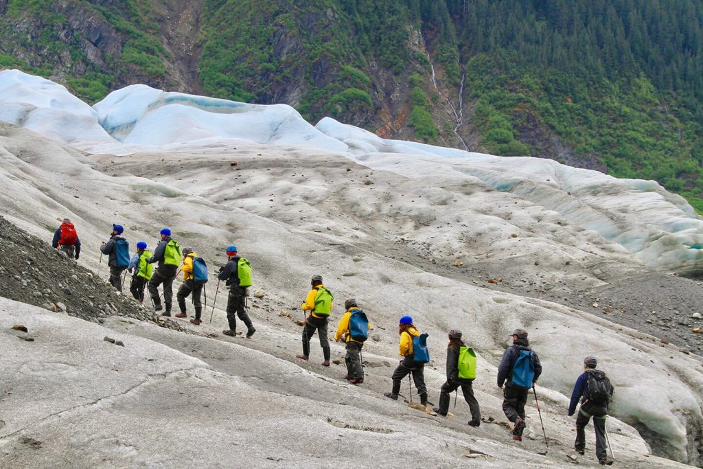
To define Glacier Hiking in Alaska as a mere recreational activity is to overlook the glaciological and technical prerequisites necessary for safe passage. At its core, this is a multi-disciplinary pursuit that sits at the intersection of mountaineering, geology, and meteorology. The phrase encompasses everything from a two-hour walk on the relatively stable “dry ice” of the Root Glacier to multi-day expeditions across the massive Root or Matanuska ice complexes.
A primary misunderstanding involves the perceived stability of the surface. Many novices assume that because the ice is centuries old, it is immovable. In reality, the “active” glaciers of the Alaska Range or the St. Elias Mountains can move several feet per day. This movement creates a labyrinth of crevasses and fissures in the ice that are often hidden by seasonal snow bridges. Oversimplification of this risk is the leading cause of accidents. The “adventure” component is therefore not about physical exertion alone, but about the constant, high-stakes interpretation of visual cues in the ice.
From a glaciological perspective, the hiker is navigating the “ablation zone,” the area of the glacier where annual melting exceeds snow accumulation. This results in “bare ice” during the summer months, which is structurally different from the “accumulation zone” higher up. Understanding these zones is critical; what is a simple walk in July may become a high-risk technical ascent in May due to snow cover concealing deep hazards.
Deep Contextual Background
Alaska’s glacial history is rooted in the Pleistocene epoch, but the specific formations encountered by modern hikers are largely shaped by the Little Ice Age (LIA), which peaked in the mid-19th century. During this period, glaciers reached their maximum extent, carving the deep valleys and fjords that define the state’s coastline. As the LIA ended, a period of general retreat began, a process that has accelerated exponentially over the last three decades.
The systemic evolution of these glaciers is governed by the Mass Balance, the difference between how much snow a glacier gains and how much ice it loses. In Alaska, this balance is increasingly negative. This has led to the emergence of “stagnant ice” sections, where the glacier is no longer flowing but is melting in place, often covered by a layer of insulating dirt and rocks. These areas, known as “debris-covered glaciers,” present a unique navigational challenge: they look like solid ground but are actually honeycombed with internal meltwater tunnels and sinkholes (moulins).
The history of exploration on these glaciers has moved from the purely scientific expeditions of the early 20th century to a structured tourism industry. However, the “wild” nature of Alaskan ice remains. Unlike the Alps, where many glaciers are serviced by cable cars and groomed paths, Alaskan glaciers generally require significant “bushwhacking” or helicopter access, preserving a level of difficulty and isolation that demands self-sufficiency.
Conceptual Frameworks and Mental Models
Navigating the ice requires a set of cognitive frameworks to process the immense amount of environmental data.
1. The River Model
One must visualize the glacier as a fluid, albeit slow-moving, river. Where the “river” bends or goes over a steep drop in the bedrock, the surface ice (which is brittle) must crack to accommodate the movement of the plastic ice below. This creates predictable patterns:
-
Transverse Crevasses: Form perpendicular to the flow where the glacier steepens.
-
Marginal Crevasses: Form at the edges where the ice is slowed by friction against valley walls.
-
Constraint: This model fails when the bedrock is irregular, creating “ice falls” where the crevasse patterns become chaotic and unnavigable.
2. The Albedo Feedback Loop
This is a thermodynamic model essential for safety. Darker surfaces (dirt, rocks, soot) absorb more solar radiation than white ice.
-
Application: A hiker should recognize that areas of “dirty” ice will melt faster, creating unstable “dirt cones” or causing large boulders (glacial erratics) to suddenly shift as their icy pedestals give way.
-
Limit: This model is highly weather-dependent; on overcast days, the melt rate flattens, changing the stability of the terrain.
3. The Time-of-Day Safety Window
Glacial stability is highest in the early morning when the overnight freeze has solidified surface meltwater and snow bridges.
-
Framework: As the sun rises, “glacier rivers” (supraglacial streams) swell, and the risk of rockfall from lateral moraines increases.
-
Limit: In the height of the Alaskan summer, the “midnight sun” can prevent a deep freeze, rendering this window shorter or non-existent.
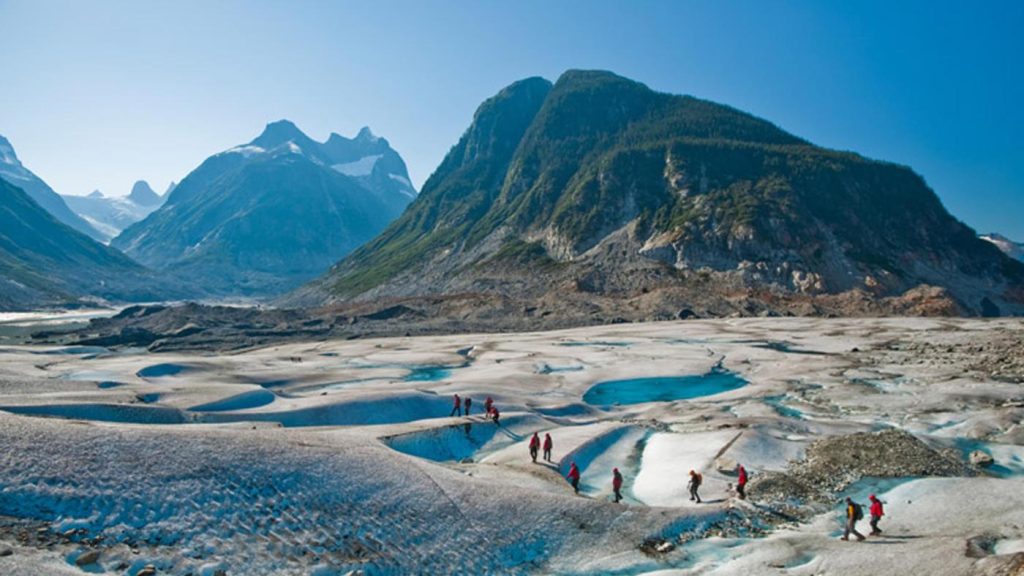
Key Categories of Glacial Terrain
Glacier hiking is not a uniform experience. The terrain is categorized by its position on the glacier and its level of activity.
| Terrain Type | Description | Technical Difficulty | Risk Profile |
| Terminus/Toe | The lowest end often ends in a lake or moraine. | Low to Moderate | High (Calving and collapse) |
| Ablation Zone (Dry Ice) | Exposed blue ice with no snow cover. | Moderate | Low (Hazards are visible) |
| Moraine/Debris Cover | Ice is buried under rock and silt. | Moderate | High (Unstable footing/sinkholes) |
| Ice Fall | Steep, heavily fractured area of rapid flow. | Expert Only | Extreme (Serac falls) |
| Firn/Accumulation Zone | Upper reaches are covered in perennial snow. | High | Extreme (Hidden crevasses) |
Decision Logic for Route Selection
When approaching a glacier entrance, the hiker must choose between the “center line” and the “lateral margins.”
-
Center Line: Usually smoother ice but more exposed to wind and further from “exit” points.
-
Margins: Easier to access but plagued by “moats” (deep gaps between ice and rock) and frequent rockfall from the valley walls.
-
Logic: If the temperature is rising, move toward the center to avoid rockfall. If visibility is dropping, stay toward the margins to maintain a terrestrial reference point.
Detailed Real-World Scenarios
The Hidden Moulin
While walking on the Matanuska Glacier, a hiker encounters a flat, gravel-covered area that appears to be a stable “island.”
-
The Constraint: This gravel is actually a thin veneer over a moulin—a vertical shaft carved by meltwater.
-
Decision Point: The hiker must test the ground with an ice axe or trekking pole.
-
Failure Mode: Trusting visual “terrestrial” cues in a glacial environment, leading to a fall into an internal drainage system.
The Swelling Supraglacial Stream
On the Mendenhall Glacier, a trekker crosses a small stream at 10:00 AM. Upon returning at 4:00 PM, the stream has become a roaring torrent too wide to jump.
-
Second-Order Effect: The hiker is forced to travel up-glacier to find a narrower crossing, moving into more fractured, dangerous ice as daylight fades.
-
Constraint: The inability to “wade” in glacial water due to immediate hypothermia and the risk of being swept into a crevasse.
The Sudden Whiteout
An unguided party on the Exit Glacier is caught in a “katabatic wind” whiteout—cold air rushing down from the ice field.
-
Decision Point: Shelter in place on the ice or attempt to navigate via GPS to the moraine.
-
Failure Mode: Moving during zero visibility on a glacier, where a single misstep leads to a crevasse, versus staying still and risking exposure/hypothermia.
Planning, Cost, and Resource Dynamics
beyondak.com
The economics of Glacier Hiking in Alaska are influenced by the extreme geography. Unlike lower-latitude hiking, “free” access is rare because the ice is often separated from the road system by impenetrable brush or dangerous rivers.
Direct and Indirect Costs
-
Access: Helicopter “drop-offs” are the gold standard for reaching stable interior ice, costing between $400 and $700 per person.
-
Gear: Technical hardware (crampons, ice axes, helmets, harnesses) requires significant investment or high rental fees.
-
Opportunity Cost: Choosing a “road-accessible” glacier like the Matanuska often involves crowds and “pay-to-play” access fees, whereas remote glaciers require days of approach time that could be used for actual ice trekking.
| Resource | Guided Day Trip | Self-Supported Expedition |
| Cost Range | $200 – $600 | $1,500 – $5,000+ |
| Permits | Usually included | Often requires NP/Forest Service permits |
| Skill Requisite | Basic fitness | Advanced crevasse rescue & navigation |
| Equipment | Provided | Must own/rent technical kit |
Tools, Strategies, and Support Systems
To safely engage with the ice, one must utilize a specific “support system” of gear and strategy.
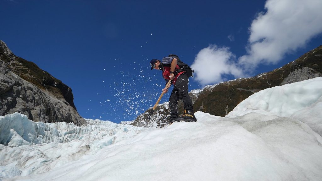
-
Crampons: Not simple “traction cleats.” True 10- or 12-point crampons are necessary to bite into the hard, high-density Alaskan blue ice.
-
The Ice Axe: Serves as a “third leg” for stability and a “brake” for self-arrest, but primarily as a tool for probing the density of the ice.
-
Roped Travel Systems: In snow-covered zones, being “roped up” with a team is the only way to mitigate hidden crevasse falls. This requires knowledge of “Z-pulley” rescue systems.
-
Satellite Messengers: Essential. Glaciers sit in “deep” valleys that block traditional radio and cell signals.
-
Stiff-Soled Mountaineering Boots: Essential for crampon compatibility; soft hiking boots can cause crampons to pop off at critical moments.
-
Polarized Eye Protection: “Snow blindness” (photokeratitis) can occur in hours due to the high UV reflection off the ice.
-
Layered Kinetic Clothing: The temperature on the ice can be 20 degrees colder than on the shore, with high wind chill factors.
Risk Landscape and Failure Modes
The “Risk Taxonomy” of a glacier is unique because the hazards are often compounding.
1. Objective Hazards (Environmental)
-
Calving: The sudden breaking of ice chunks at the terminus. On a water-terminating glacier, this can create mini-tsunamis.
-
Serac Collapse: Massive towers of ice on steep sections that can fall without warning, regardless of temperature.
2. Subjective Hazards (Human)
-
Heuristic Traps: “Social proof” (following others’ tracks) is deadly on a glacier, as a snow bridge that held one person may fail for the second.
-
Complacency: The “flat ice” sections feel safe, leading hikers to remove helmets or unrope just before entering a high-risk zone.
3. Compounding Failure Example
A hiker twists an ankle on an unstable moraine (Initial Failure). Because they are on the ice, they cannot be easily evacuated by a litter (Compounding Factor). The ice surface accelerates the onset of shock and hypothermia (Biological Compounding), and the narrow valley prevents a helicopter from landing in high winds (Environmental Compounding).
Governance, Maintenance, and Long-Term Adaptation
The “governance” of Alaskan glaciers is a patchwork of federal (National Park Service), state, and private oversight. However, the true governor is the climate.
Adaptation Strategies for the Trekker:
-
Terminus Monitoring: Always check recent satellite imagery or local ranger reports. A glacier that was accessible last year may now be separated from land by a new meltwater lake.
-
Review Cycles: Professional guides in Alaska perform “scouting” runs every 48 hours to recalibrate routes as the ice moves and melts.
-
Adjustment Triggers: Any sustained temperature above 60°F or a heavy rain event should trigger an immediate “no-go” for technical or fractured sections.
Layered Safety Checklist:
-
Crampon Fit: Tested on a slope before entering the main ice body.
-
Probe Test: Use poles/axes to check every “discolored” patch of ice.
-
Exit Strategy: Identify the nearest “non-ice” ground at all times.
-
Communication Check: Satellite ping sent and received by a home contact.
Measurement, Tracking, and Evaluation
How does one “measure” a successful glacier trek? It is not by distance, but by the maintenance of safety margins.
-
Leading Indicators: Consistent pace, frequent hydration, and “reading” the ice 100 meters ahead of the current position.
-
Lagging Indicators: Unplanned “forced” jumps over crevasses, losing gear in a stream, or returning after dark.
-
Qualitative Signals: The “sound” of the glacier. A “quiet” glacier is often more stable; frequent “cracking” or the sound of rushing water indicates high melt and movement.
Documentation Examples:
-
Waypointing: Marking the “safe” entrance through a moraine on a GPS to find the exit in a whiteout.
-
Photo-Monitoring: Taking “terminal” photos to contribute to citizen science databases tracking glacial retreat.
-
Incident Logging: Even a “near miss” (a foot slipping into a small crack) should be documented to adjust future decision-making.
Common Misconceptions and Oversimplifications
-
Myth: Crampons make you invincible. Correction: They only provide traction; they do not prevent a crevasse from opening under you.
-
Myth: Glaciers are white. Correction: Healthy glaciers are often deep blue due to the compression of air bubbles; “white” ice is often aerated and less stable.
-
Myth: You can outrun a calving event. Correction: The displacement waves and falling ice move at speeds that make reaction time nearly irrelevant if you are too close.
-
Myth: Only “active” glaciers are dangerous. Correction: “Stagnant” ice is often more dangerous because it is unpredictable and hidden under debris.
-
Myth: Hiking poles are as good as an ice axe. Correction: Poles cannot be used for self-arrest or to chop steps in an emergency.
-
Myth: GPS is all you need. Correction: GPS does not show crevasses, which can open overnight.
Ethical and Contextual Considerations
The ethics of Glacier Hiking in Alaska revolve around the “Leave No Trace” principles in an environment that does not process waste. Human waste and trash dropped on a glacier are “preserved” in the ice for years, eventually emerging at the terminus. Furthermore, there is a “Last Chance Tourism” dilemma: the carbon footprint of traveling to see these melting giants contributes to their disappearance. Trekking with a mindset of “witnessing” rather than “conquering” is the professional editorial standard.
Conclusion
Alaska’s glaciers are the planet’s most visceral reminder of the power and fragility of the natural world. Engaging in a Road Trip Adventure on Route 66 or trekking across the Root Glacier both require navigation of the American landscape, but the latter demands a specialized communion with the laws of physics. Glacier hiking is an exercise in profound presence; the ice demands total attention to the “now,” as the terrain you stand on is literally disappearing beneath your feet.
The successful ice trekker views the glacier as a mentor, a teacher of humility, risk assessment, and environmental stewardship. As the cryosphere continues to shrink, the opportunity to walk on these ancient structures becomes more precious and more precarious. It is a pursuit that rewards the patient, the prepared, and the intellectually honest, offering a perspective on time and scale that no other terrestrial environment can provide.