
dirganews.com – The network known as the Kumano Kodo illustrates this tension with unusual clarity. Often presented as Japan’s answer to Europe’s medieval walking traditions, it is in fact a layered system of routes shaped by imperial ritual, syncretic religion, regional geography, and modern tourism infrastructure. Any attempt to understand it purely as a hiking destination misses the deeper structure that governs its experience.
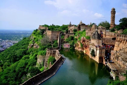
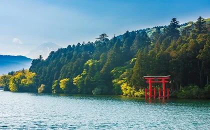
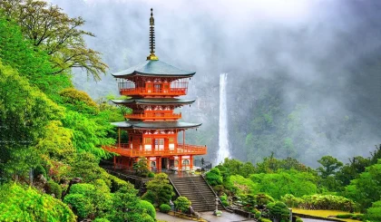
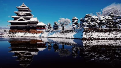
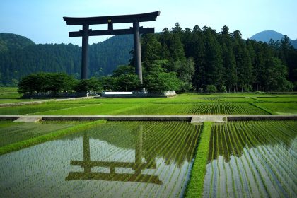
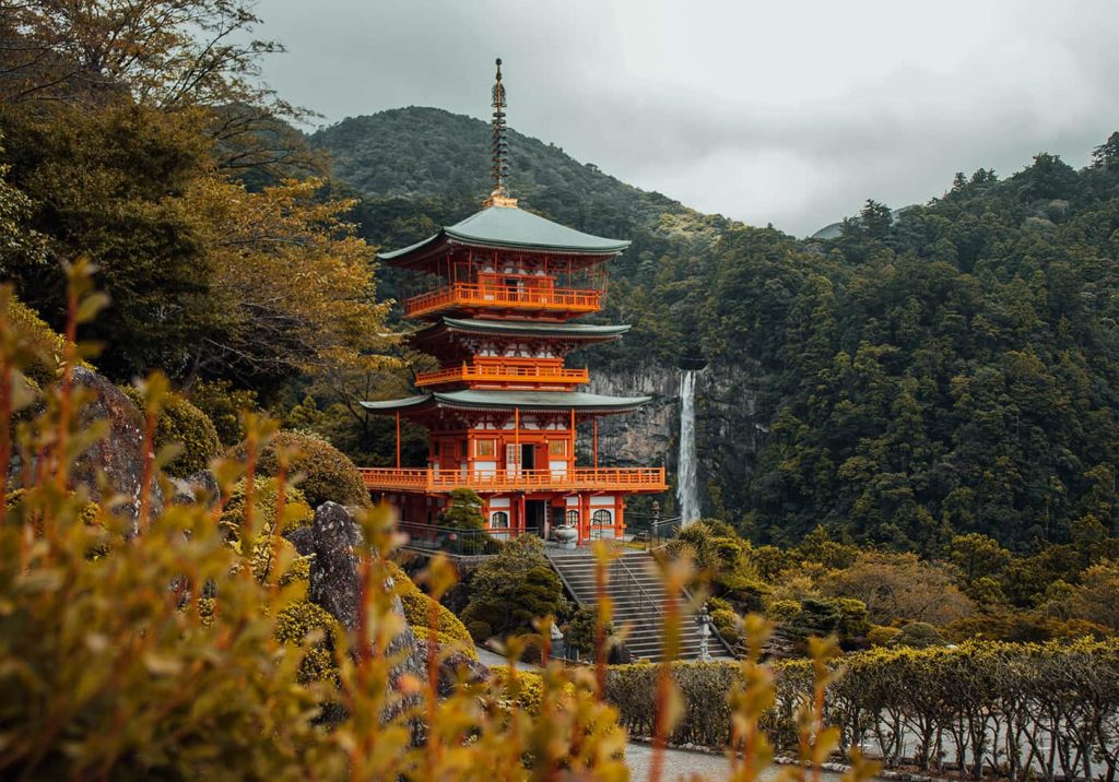
The terrain itself contributes to this complexity. The routes wind through the mountainous Kii Peninsula, where humidity, dense forest, and shifting weather patterns complicate what might otherwise be straightforward navigation. At the same time, the cultural landscape is inseparable from the physical one. Shrines such as Kumano Hongu Taisha and Kumano Nachi Taisha are not endpoints in a recreational sense; they are nodes in a system that historically framed the entire journey as a spiritual undertaking.
Modern interpretations tend to compress this into a manageable narrative: a scenic multi-day hike with cultural highlights. That framing is not wrong, but it is incomplete. The experience is shaped as much by logistical decisions, route selection, accommodation sequencing, and pacing as by historical awareness and environmental conditions.
This article approaches the subject as a long-form editorial analysis rather than a guidebook checklist. The aim is not only to describe what the Kumano Kodo hiking involves, but to unpack the structures, trade-offs, and decision frameworks that determine how it unfolds in practice.
Kumano Kodoo hiking.
hiking-trails.com
At a surface level, Kumano Kodoo hiking refers to traversing one or more pilgrimage routes across the Kii Peninsula, typically over several days, linking historic shrines collectively known as the Kumano Sanzan. That definition is serviceable but reductive.
A more accurate interpretation requires three simultaneous lenses:
1. Pilgrimage System
Historically, these routes were not optional trails but prescribed pathways for religious practice. The journey itself, its hardship, duration, and ritual stops were integral to meaning. Removing that context changes not only the purpose but the pacing and structure of the experience.
2. Distributed Trail Network
Unlike linear long-distance trails, the Kumano Kodo is a network with multiple entry points, overlapping segments, and varying levels of preservation. The Nakahechi Route, for example, functions differently from the more remote Kohechi Route in both terrain and logistical requirements.
3. Managed Tourism Corridor
In its modern form, Kumano Kodo hiking operates within a structured tourism ecosystem. Luggage transfer services, pre-booked accommodations, and mapped itineraries create a semi-curated experience that contrasts sharply with the historical model.
Common Misunderstandings
- Equating it with a single trail: The system includes multiple routes, each with distinct characteristics.
- Assuming uniform difficulty: Terrain ranges from gentle forest paths to steep mountain crossings.
- Overemphasizing spirituality: While still present, the experience is often secular for visitors today.
- Underestimating logistics: Accommodation spacing and transport access significantly shape the journey.
The risk of oversimplification is practical. Decisions made under incomplete assumptions, such as selecting an unsuitable route or underestimating travel times, tend to compound quickly once on the trail.
Deep Contextual Background
The origins of the Kumano Kodo trace back over a millennium, tied to the rise of pilgrimage culture during Japan’s Heian period. Aristocrats and later commoners traveled from Kyoto toward the Kumano region, seeking spiritual renewal through visits to sacred sites embedded in nature.
This evolution was not linear. The routes expanded, contracted, and shifted in importance depending on political power, religious influence, and infrastructure changes. The designation of the area as part of the UNESCO World Heritage Site formalized its global significance, but also introduced new pressures related to preservation and tourism.
Several structural dynamics emerged over time:
- Syncretism: The blending of Shinto and Buddhist practices shaped the meaning of the journey.
- Regional Isolation: Geographic barriers preserved certain routes while rendering others less accessible.
- Modern Reinterpretation: Tourism frameworks redefined access, pacing, and expectations.
Conceptual Frameworks and Mental Models
1. The Continuum Model (Pilgrimage ↔ Recreation)
At one end lies traditional pilgrimage; at the other, recreational hiking. Most modern experiences fall somewhere between.
Limit: This model can obscure the hybrid nature of the journey, where elements of both coexist unpredictably.
2. The Constraint Stack
Each decision layer, time, budget, physical ability, and accommodation availability adds constraints that narrow feasible itineraries.
Limit: Overemphasis on constraints may lead to overly conservative planning.
3. The Network Navigation Model
Rather than a linear path, the Kumano Kodo operates as a network with nodes (villages, shrines) and edges (trail segments).
Limit: This abstraction can overlook qualitative differences between segments.
4. The Experience Density Framework
Some routes compress cultural and scenic highlights into shorter distances, while others distribute them more sparsely.
Limit: High density can lead to overcrowding, reducing perceived value.
5. The Resilience Model
The ability to adapt to disruptions, weather, fatigue, and missed transport often determines overall success.
Limit: Resilience planning can conflict with rigid booking systems.
Key Route Categories and Variations
Major Routes
- Nakahechi Route – Most commonly traveled, balanced accessibility, and cultural sites
- Kohechi Route – Mountainous, physically demanding, fewer facilities
- Iseji Route – Coastal sections with varied terrain
- Ohechi Route – Scenic coastal paths, less trafficked
- Omine Okugake – Ascetic route with religious restrictions
- Kii Peninsula Loop Variants – Custom itineraries combining segments
Comparison Table
| Route | Difficulty | Infrastructure | Crowd Level | Scenic Type | Flexibility |
|---|---|---|---|---|---|
| Nakahechi | Moderate | High | High | Forest + Shrines | High |
| Kohechi | High | Low | Low | Mountain Ridges | Low |
| Iseji | Moderate | Medium | Medium | Coastal + Forest | Medium |
| Ohechi | Moderate | Low | Low | Coastal | Medium |
| Omine | Very High | Very Low | Very Low | Alpine/Religious | Very Low |
Decision Logic
Selecting a route is less about preference and more about alignment with constraints. For example:
- Limited time → Nakahechi segment
- High fitness + low crowd tolerance → Kohechi
- Scenic diversity → Iseji
Real-World Scenarios and Decision Dynamics
Limited Time, Moderate Fitness
A traveler with 3–4 days and average conditioning may choose a partial Nakahechi route.
Failure mode: Overpacking itinerary → fatigue → missed accommodations.
High Fitness, Low Infrastructure PreferenceThe
Kohechi route offers solitude.
Second-order effect: Limited resupply increases logistical complexity.
Cultural Emphasis Over Physical Challenge
Shorter segments near major shrines.
Constraint: Higher crowd density reduces immersion.
Seasonal Constraints (Rainy Season)
Heavy rainfall impacts trail conditions.
Decision point: Adjust pacing vs. reroute.
Mixed-Group Ability Levels
Group dynamics require compromise.
Outcome risk: Weakest member determines pace.
Planning, Cost, and Resource Dynamics
| Category | Typical Range (USD) | Variability Factors |
|---|---|---|
| Accommodation/night | $80–$250 | Season, meal inclusion |
| Transport | $20–$100 | Distance, train vs. bus |
| Luggage Transfer | $15–$30/day | Distance, provider |
| Food (additional) | $10–$40/day | Availability in rural areas |
| Miscellaneous | $20–$100 | Gear, entry fees, contingencies |
Indirect costs include opportunity cost (time allocation) and recovery time post-hike.
Tools, Strategies, and Support Systems
- Route mapping platforms
- Local tourism booking systems
- Luggage forwarding services
- Weather tracking tools
- Trail signage (physical markers)
- Accommodation coordination networks
- Emergency communication devices
Each tool reduces uncertainty but introduces dependency. For example, luggage transfer simplifies daily travel but reduces flexibility in route changes.
Risk Landscape and Failure Modes
Primary Risks:
- Weather variability
- Physical fatigue or injury
- Navigation errors
- Accommodation mismatches
Compounding Risks:
- Tight scheduling + weather delays
- Overestimation of fitness + steep terrain
- Limited communication access in remote areas
Governance, Maintenance, and Long-Term Adaptation
The long-term integrity of the Kumano Kodo depends on a governance and stewardship model that is inherently dynamic. Unlike purpose-built hiking infrastructure, this network must simultaneously function as a protected cultural landscape, an active religious corridor, and a contemporary travel route. These overlapping roles create a system where maintenance is not purely technical, and governance is not purely administrative; both are shaped by evolving priorities and constraints.
Governance Architecture: Distributed Authority with Shared Objectives
Responsibility for the Kumano Kodo is distributed across multiple layers rather than concentrated in a single managing body. Municipal governments oversee specific trail sections, regional authorities coordinate tourism strategies, and national cultural agencies provide regulatory frameworks. This structure is further influenced by its inclusion in the UNESCO World Heritage Site designation, which emphasizes preservation standards without prescribing uniform operational methods.
Several characteristics define this governance model:
- Localized Decision-Making: Towns and villages directly manage nearby trail segments, allowing for rapid responses to environmental changes or infrastructure issues.
- Regional Alignment: Prefectural coordination ensures a degree of consistency in mapping, visitor information, and branding.
- Cultural Oversight: Religious institutions associated with key sites, such as Kumano Nachi Taisha, influence how sacred areas are maintained and accessed.
This distributed approach allows for contextual sensitivity but introduces variability. Trail conditions, signage clarity, and service availability can differ across segments, reflecting local priorities and resource levels.
Maintenance Systems: Continuous Stewardship Under Environmental Pressure
Maintenance on the Kumano Kodo is best understood as a continuous process rather than periodic intervention. The environmental conditions of the Kii Peninsula, heavy rainfall, dense vegetation, and steep terrain, accelerate wear and require ongoing attention.
Structural Preservation
Many sections of the trail are composed of historic stone paving or traditional pathways. Maintenance efforts focus on stabilization rather than replacement. Stones are reset, drainage systems are reinforced, and steps are repaired using techniques that preserve historical character.
Vegetation Control
Rapid plant growth can obscure paths within short timeframes. This balance is critical; excessive clearing would alter the landscape, while insufficient action compromises usability.
Wayfinding and Information Systems
Trail markers and signage form an essential layer of maintenance. Updates are required not only due to physical wear but also because of route changes, hazard alerts, and evolving visitor needs. Multilingual signage has expanded in response to international interest, but its integration is carefully managed to avoid visual intrusion.
A defining constraint across all maintenance activities is the commitment to minimal intervention. Modernizing the trail excessively would undermine its historical authenticity, so solutions tend to favor subtle reinforcement over visible transformation.
Measurement, Tracking, and Evaluation
Leading Indicators:
- Daily energy levels
- Weather forecasts
- Trail conditions
Lagging Indicators:
- Completion rate
- Injury occurrence
- Schedule adherence
Documentation Examples
- Daily log of distance and time
- Expense tracking sheet
- Route deviation notes
- Post-trip evaluation summary
Common Misconceptions and Oversimplifications
- “It’s just a hike” → ignores cultural context
- “All routes are similar” → overlooks variability
- “Easy logistics” → underestimates coordination
- “Weather is predictable” → often incorrect
- “Fitness alone determines success” → incomplete
- “Short routes lack value” → false trade-off
- “More days = better experience” → not always
- “Technology solves everything” → partial truth
Ethical and Contextual Considerations
- Respect for sacred sites remains central
- Local community impact from tourism
- Environmental preservation of forest trails
- Balancing accessibility with authenticity
Conclusion
Kumano kodo hiking resists reduction to a single narrative. It is simultaneously a historical pilgrimage system, a modern trekking network, and a managed cultural landscape. Each of these layers introduces variables that shape the experience in ways that are not immediately visible from standard travel descriptions. Route selection, pacing, logistical planning, and contextual awareness all influence outcomes, often in nonlinear ways. The same trail can feel contemplative or transactional, immersive or fragmented, depending on how those elements align.
FAQ
1. What is the best route for first-time visitors?
For most first-time travelers, the Nakahechi Route is the most practical starting point. It offers a balanced combination of cultural landmarks, well-maintained trails, and accessible accommodations.
2. How difficult is the Kumano Kodo hiking?
Difficulty varies significantly depending on the chosen route and segment. While some sections involve gentle forest paths, others, particularly on routes like the Kohechi Route, include steep ascents, long distances between services, and physically demanding terrain.
3. How many days are needed to complete the Kumano Kodo?
There is no single answer because the Kumano Kodo is not a single trail. A typical itinerary along the Nakahechi Route takes 3 to 5 days, covering key sections between trailheads and major shrines such as Kumano Hongu Taisha.