dirganews.com – The Gobi is often introduced as a place of extremes, but that framing tends to obscure more than it reveals. Extremes are not its defining feature so much as the way those extremes interact. Temperature, wind, soil composition, and moisture availability do not simply fluctuate independently; they combine in ways that produce a system that is difficult to predict and resistant to simplification. What appears barren is, in fact, structured subtly, unevenly, and often in ways that only become visible over time.
Within the borders of Mongolia, the desert assumes a particular character shaped by elevation, continental isolation, and long-standing patterns of human adaptation. It is colder than most deserts commonly referenced in global discourse, and its seasonal contrasts are sharper. Winter does not soften the landscape; it intensifies its constraints. Summer does not bring abundance in the conventional sense; it introduces a brief, uneven redistribution of limited resources.
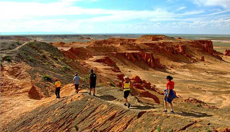
Visual expectations remain misleading. The dominant image, rolling dunes under relentless sun, captures only fragments of the terrain. Much of the surface is composed of gravel plains, rock formations, and semi-arid steppe that transitions gradually rather than abruptly. The result is not a single landscape but a shifting mosaic of conditions, each responding differently to wind, temperature, and scarce precipitation.
Understanding “Gobi Desert, Mongolia.”
www.mongoliashorttours.com
The phrase “Gobi Desert, right Mongolia” is often used as if it were self-explanatory. In practice, it compresses multiple layers of meaning into a single label. At the most basic level, it refers to the northern portion of the broader Gobi system, situated within Mongolia’s political boundaries. Yet the phrase carries implicit assumptions about climate, terrain, and human presence that deserve closer examination.
A primary source of confusion lies in the definition of a desert. Popular imagery equates deserts with heat and sand, but scientific classification depends on aridity. The Gobi qualifies because of its low precipitation, not because of its temperature or surface composition. This distinction is not trivial. It explains why large sections of the desert are cold for much of the year, and wind dunes, though present, are not the dominant landform.
The Mongolian segment of the Gobi introduces additional complexity. Elevation contributes to lower temperatures, while continental positioning amplifies seasonal variation. Winters can be severe enough to affect both ecological processes and human systems. These conditions produce a type of desert that behaves differently from those shaped primarily by heat.
Deep Contextual Background
The Gobi’s current form is the result of long-term geological and climatic processes. Among the most significant is the uplift of the Himalayas, which altered atmospheric circulation patterns across Central Asia. This uplift created a rain shadow effect, limiting the amount of moisture that reaches the region. Over time, this reduction in precipitation contributed to the development of arid and semi-arid conditions.
This transformation did not occur uniformly. Geological evidence suggests that the region has undergone multiple phases of environmental change. Fossil discoveries, particularly in areas known for rich paleontological deposits, indicate that the Gobi once supported ecosystems far more diverse than those seen today. These findings highlight the desert’s dynamic history.
Human interaction with the Gobi reflects this variability. During the era of the Silk Road, the desert functioned as both obstacle and conduit. Trade routes crossed its expanse, requiring careful planning and reliance on limited water sources. Knowledge of the landscape, pe its seasonal patterns, and its navigable paths was essential.
The expansion of the Mongol Empire under Genghis Khan further integrated the region into a broader network of movement. Mobility, already central to pastoral life, became a strategic advantage. The desert was not a barrier in the conventional sense; it was a space that shaped how movement occurred.
In the modern period, new dynamics have emerged. Resource extraction, particularly mining, has introduced infrastructure and economic activity into previously remote areas. At the same time, climate variability has intensified, influencing precipitation patterns and temperature extremes. These changes interact with land-use practices, contributing to shifts that are often described as desertification.
The Gobi’s background is not a single narrative but a convergence of processes operating across different scales. Geological history, ecological dynamics, and human decisions continue to shape its evolution.
Conceptual Frameworks and Mental Models
Understanding the Gobi requires frameworks that can accommodate complexity without reducing it.
- Scarcity-Oriented Thinking
Water and vegetation are limited, and this scarcity shapes behavior across the system. Adaptations both biological and cultural are responses to this constraint.
Limit: This framework can understate resilience and adaptability.
- Mobility as System Design
Movement replaces fixed infrastructure. Nomadic herding systems rely on flexibility, using space as a resource.
Limit: External pressures, including land-use restrictions, can disrupt mobility.
- Gradient-Based Ecology
The Gobi exists along a continuum between steppe and desert. Conditions shift gradually rather than abruptly.
Limit: Gradients complicate classification and management.
- Variability-Centered Planning
Extreme fluctuations, rather than averages, define outcomes.
Limit: High variability reduces predictability.
- Resource Frontier Perspective
The region is viewed as an area of economic potential, particularly for mineral extraction.
Limit: This perspective may overlook ecological and cultural dimensions.
Key Categories and Environmental Variations
The Gobi is composed of multiple landscape types, each with distinct characteristics.
Major Categories
- Gravel Plains
- Rocky Plateaus
- Sand Dune Fields
- Salt Flats
- Semi-Arid Steppe
- Mountain Zones
- Dry Riverbeds
Comparative Table
| Landscape Type | Water Availability | Vegetation | Accessibility | Stability |
|---|---|---|---|---|
| Gravel Plains | Very Low | Sparse | Moderate | High |
| Sand Dunes | Low | Minimal | Difficult | Low |
| Steppe Zones | Moderate | Moderate | High | Moderate |
| Salt Flats | Seasonal | Minimal | Variable | Low |
| Mountain Zones | Higher | Diverse | Difficult | High |
| Riverbeds | Episodic | Variable | Moderate | Low |
Decision Logic
Different activities interact with these landscapes in distinct ways. Mobility strategies, water sourcing, and risk exposure all depend on terrain type. Decisions involve balancing competing priorities rather than optimizing a single variable.
Real-World Scenarios and Operational Realities
- Nomadic Herding
Adaptation is continuous. Movement responds to shifting conditions.
Failure Mode: Restricted mobility leads to overgrazing.
Second-Order Effect: Reduced long-term productivity.
- Scientific Research
Fieldwork requires logistical resilience.
Failure Mode: Equipment failure due to environmental stress.
Second-Order Effect: Loss of data integrity.
- Mining Operations
Infrastructure must operate under constraints.
Failure Mode: Environmental mismanagement.
Second-Order Effect: Long-term degradation.
- Conservation Programs
Balancing protection with use.
Failure Mode: Ignoring local knowledge.
Second-Order Effect: Policy failure.
- Tourism Systems
Managing access to fragile environments.
Failure Mode: Overdevelopment.
Second-Order Effect: Environmental decline.
Planning, Cost, and Resource Dynamics
Cost Table
| Category | Low Range | High Range | Key Variables |
|---|---|---|---|
| Transport | Moderate | High | Distance |
| Water Supply | Low | Very High | Availability |
| Equipment | Moderate | High | Durability |
| Labor | Variable | High | Skill Level |
| Risk Mitigation | Moderate | High | Conditions |
Indirect costs include environmental impact and opportunity costs.
Tools, Strategies, and Support Systems
- Satellite navigation
- Weather monitoring systems
- Mobile water storage
- Terrain-adapted vehicles
- Integration of local knowledge
- Redundant communication
- Seasonal planning
Each tool has limits and must be integrated.
Risk Landscape and Failure Modes
Risks are interconnected:
- Environmental
- Operational
- Human
- Systemic
Failures often cascade rather than remain isolated.
Governance, Maintenance, and Long-Term Adaptation
Governance in the Gobi is less about imposing fixed structures and more about managing variability across time and space. The environment does not lend itself to rigid systems. Conditions shift seasonally, sometimes abruptly, and any framework that assumes stability is likely to fail. Effective governance, therefore, tends to be adaptive, layered, and responsive rather than prescriptive.
This becomes particularly evident in the context of the Gobi Desert Mongolia, where environmental constraints intersect with economic ambitions and long-standing pastoral traditions. The challenge is not simply regulation but coordination aligning land use, resource extraction, and ecological preservation without assuming that a single model can apply uniformly across the region.
Monitoring Systems and Environmental Awareness
Monitoring is the foundation of any governance strategy in a variable environment. It serves not only as a diagnostic tool but as an early-warning mechanism.
Key areas of focus include:
- Climate Patterns: Tracking temperature extremes, precipitation variability, and wind intensity
- Vegetation Dynamics: Observing changes in pasture health and distribution
- Water Availability: Monitoring both surface and subsurface sources
- Land Use Patterns: Identifying shifts in grazing intensity, infrastructure expansion, and settlement
The challenge lies in integrating different types of data. Satellite observations provide broad coverage but may miss localized nuances. Ground-based observations, often informed by herders and local communities, offer detailed insight but may lack standardization. Effective systems combine both.
Review Cycles and Temporal Structuring
Governance in the Gobi cannot rely on static planning horizons. Instead, it operates through layered review cycles that reflect different time scales.
- Seasonal Reviews: Assess immediate conditions, such as pasture availability and weather anomalies
- Annual Evaluations: Identify trends in resource use and environmental change
- Multi-Year Assessments: Examine long-term shifts, including climate patterns and land degradation
These cycles are not merely administrative. They shape decision-making by determining when adjustments are necessary. A delayed response in a variable environment can amplify risk.
Adjustment Triggers and Decision Thresholds
Adaptive governance depends on clearly defined triggers—conditions that signal the need for intervention or change.
Examples include:
- Significant deviations from expected precipitation levels
- Rapid decline in vegetation cover in key grazing areas
- Water scarcity reaching thresholds that threaten livestock or infrastructure
- Increased frequency of extreme weather events
The difficulty lies in setting thresholds that are neither too sensitive nor too rigid. Overreaction can disrupt existing systems, while delayed action can allow problems to escalate.
Maintenance as a Continuous Process
Maintenance in the Gobi extends beyond infrastructure. It includes ecological and social systems that require ongoing attention.
Infrastructure Maintenance:
Roads, wells, and communication systems must withstand extreme conditions. Dust, temperature fluctuations, and isolation increase wear and complicate repair logistics.
Ecological Maintenance:
Pasture management, erosion control, and water conservation are essential to sustaining long-term productivity. These processes often rely on practices developed over generations.
System Maintenance:
Institutional coordination, policy enforcement, and knowledge sharing require continuous effort. Governance structures must remain flexible enough to adapt while maintaining coherence.
Layered Governance Approach
A single governance model is insufficient for the Gobi. Instead, a layered approach is more effective:
- Local Level:
Community-based decision-making informed by experiential knowledge - Regional Level:
Coordination of land use, infrastructure, and resource management - National Level:
Policy frameworks that balance economic development with environmental protection - Cross-Border Considerations:
Since the Gobi extends beyond Mongolia, broader coordination may be necessary for certain issues, such as climate and biodiversity
These layers must interact without overriding one another. Centralized policies that ignore local conditions often produce unintended consequences.
Adaptation Strategies and Long-Term Resilience
Adaptation in the Gobi is not a single intervention but an ongoing process. It involves adjusting practices, technologies, and policies in response to changing conditions.
Key strategies include:
- Diversification of Livelihoods: Reducing reliance on a single resource base
- Flexible Land Use: Allowing movement and adjusting grazing patterns
- Infrastructure Modularity: Designing systems that can be scaled or relocated
- Knowledge Integration: Combining scientific data with local experience
Resilience emerges not from eliminating risk but from managing it effectively. Systems that can absorb shocks and adjust accordingly are more sustainable than those optimized for stable conditions.
Operational Checklist for Governance and Adaptation
To translate principles into practice, governance systems often rely on structured checklists:
- Map critical resources and seasonal variations
- Identify key risks and potential cascading effects
- Establish monitoring protocols with both local and technical inputs
- Define thresholds for intervention
- Coordinate stakeholders across different levels
- Develop contingency plans for extreme scenarios
- Review and update strategies regularly
This checklist is not exhaustive, but it illustrates the layered nature of decision-making required in the Gobi.
Tensions and Trade-Offs
Governance in the Gobi operates within a set of persistent tensions:
- Development vs. Conservation: Resource extraction can drive economic growth but may impact ecosystems
- Mobility vs. Regulation: Nomadic practices require flexibility, while governance often seeks structure
- Short-Term Gains vs. Long-Term Stability: Immediate benefits may undermine future resilience
These tensions cannot be fully resolved. They must be managed, with decisions informed by context and long-term perspective.
Measurement, Tracking, and Evaluation
Indicators
- Leading: vegetation trends
- Lagging: land degradation
Documentation
- Migration logs
- Resource reports
- Environmental assessments
- Operational reviews
Common Misconceptions and Oversimplifications
Misunderstandings about the Gobi tend to follow familiar patterns. They often originate in visual assumptions, partial scientific knowledge, or generalized comparisons with other deserts. While each misconception contains a fragment of truth, taken at face value, they distort how the system actually functions.
1. “It’s Mostly Sand.”
This is perhaps the most persistent assumption. The mental image of a desert is usually dominated by dunes, and while dune systems do exist in parts of the Gobi, they represent only a fraction of the terrain.
Large portions of the landscape consist of gravel plains, exposed rock, and compacted soil surfaces shaped by wind erosion rather than deposition. These surfaces behave differently, retaining less loose sediment, supporting different vegetation patterns, and influencing how water moves when it appears.
Reducing the region to sand obscures its structural diversity and leads to flawed expectations about mobility, ecology, and land use.
2. “Deserts Are Always Hot.”
The Gobi complicates this assumption in a direct way. Temperature is not what defines a desert—precipitation is. As a result, the Gobi is often classified as a cold desert, with winters that can reach extreme lows.
This seasonal contrast affects nearly every aspect of the system. Soil freezes, water availability changes, and biological activity contracts dramatically. Any model that assumes consistent heat fails to account for these dynamics.
The misconception persists because global desert imagery is dominated by hot environments, making cold arid systems less intuitive.
3. “The Region Is Empty or Uninhabited.”
Low population density is often interpreted as an absence. In reality, the Gobi supports long-established human systems, particularly nomadic pastoralism.
These communities operate with a different spatial logic. Instead of fixed settlements, they rely on movement across large areas, following seasonal patterns that optimize access to pasture and water. The landscape is not empty; it is used differently.
Treating the region as uninhabited can lead to policy decisions or development models that overlook existing knowledge systems and land-use practices.
4. “It’s Ecologically Barren.”
Sparse vegetation can give the impression of ecological simplicity. In fact, the Gobi supports specialized species adapted to its constraints—both plant and animal.
Biodiversity may be lower in absolute terms compared to more fertile regions, but it is highly adapted. Small changes in moisture, elevation, or soil composition can create distinct microhabitats.
Calling the region barren overlooks this complexity and underestimates its ecological significance.
5. “Conditions Are Stati.”
Deserts are often perceived as unchanging landscapes. The Gobi, however, is defined by variability. Temperature swings, episodic rainfall, and shifting wind patterns all contribute to a system in constant flux.
Changes may not always be immediately visible, but they accumulate over time. Vegetation patterns shift, soil surfaces evolve, and human movement adjusts in response.
Assuming stability leads to planning errors, particularly in long-term projects that depend on predictable conditions.
6. “Modern Technology Solves Environmental Constraints.”
Technological tools—navigation systems, vehicles, climate monitoring—have improved the ability to operate in the Gobi. However, they do not eliminate environmental limits.
Equipment can fail under extreme conditions. Supply chains remain vulnerable to distance and terrain. Most importantly, technology cannot fully replace local knowledge developed through long-term interaction with the landscape.
The belief that technology alone is sufficient tends to underestimate the importance of context and experience.
7. “It’s Economically Marginal.”
Because of its harsh conditions, the Gobi is sometimes viewed as economically insignificant. This overlooks its role in resource extraction, particularly minerals that have global demand.
At the same time, economic activity in the region is uneven and often tied to specific sectors. Pastoralism, mining, and emerging forms of tourism coexist, sometimes in tension.
Labeling the region as marginal simplifies a complex economic landscape and ignores both its opportunities and its constraints.
Ethical and Contextual Considerations
Balancing development with conservation remains a central challenge. Decisions affect ecosystems, economies, and cultural continuity. Trade-offs must be acknowledged rather than avoided.
Conclusion
The Gobi Desert of Mongolia is best understood as a system defined by interaction between climate and terrain, between scarcity and adaptation, between human activity and environmental limits. It resists simplification because it is not static. It evolves, responds, and reshapes itself over time.
Understanding it requires patience, attention to detail, and a willingness to engage with complexity rather than reduce it.