dirganews.com – The geological and cultural narrative of the Hashemite Kingdom of Jordan finds its most profound expression in the vast, desert landscape of the south. Often termed the “Valley of the Moon,” this region represents a complex intersection of tectonic history, Nabataean archaeology, and contemporary Bedouin social structures. In 2026, as global interest in desert ecosystems shifts from mere visual consumption toward deep ecological and historical immersion, the significance of this area has evolved. It is no longer viewed simply as a cinematic backdrop, but as a critical geomorphological laboratory and a sanctuary of human adaptation to extreme aridity.
To approach this landscape through a purely recreational lens is to ignore the “Environmental Palimpsest” that defines it. The sheer sandstone and granite massifs are not static formations; they are the result of millions of years of subterranean pressure, wind erosion, and thermal expansion. Beneath the iconic red sands lies a sophisticated hydrological network of paleo-aquifers that have sustained human life for over 12,000 years. Understanding the region requires an analytical audit of its multifaceted identity, moving beyond the “Mars on Earth” tropes to examine the systemic realities of desert life and preservation.
The logistical complexity of the southern desert demands a level of intellectual and physical preparedness that distinguishes the serious investigator from the casual visitor. This is an environment defined by “Resource Scarcity” and “Climatic Volatility,” where the infrastructure is a delicate balance between nomadic traditionalism and the demands of modern conservation. Consequently, the value of a definitive reference on this territory is found in its “Contextual Depth”, the ability to synthesise petroglyphic evidence, geological data, and contemporary governance into a coherent understanding of a landscape that is as fragile as it is formidable.
Understanding “Wadi Rum Jordan”
scratchyourmapa.com
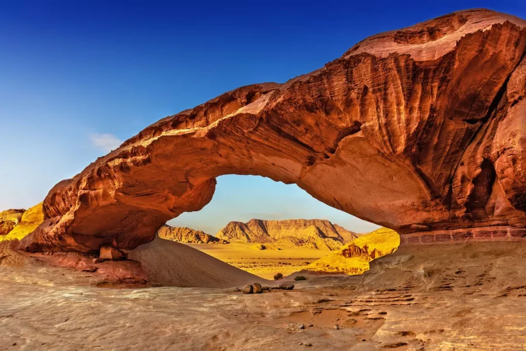
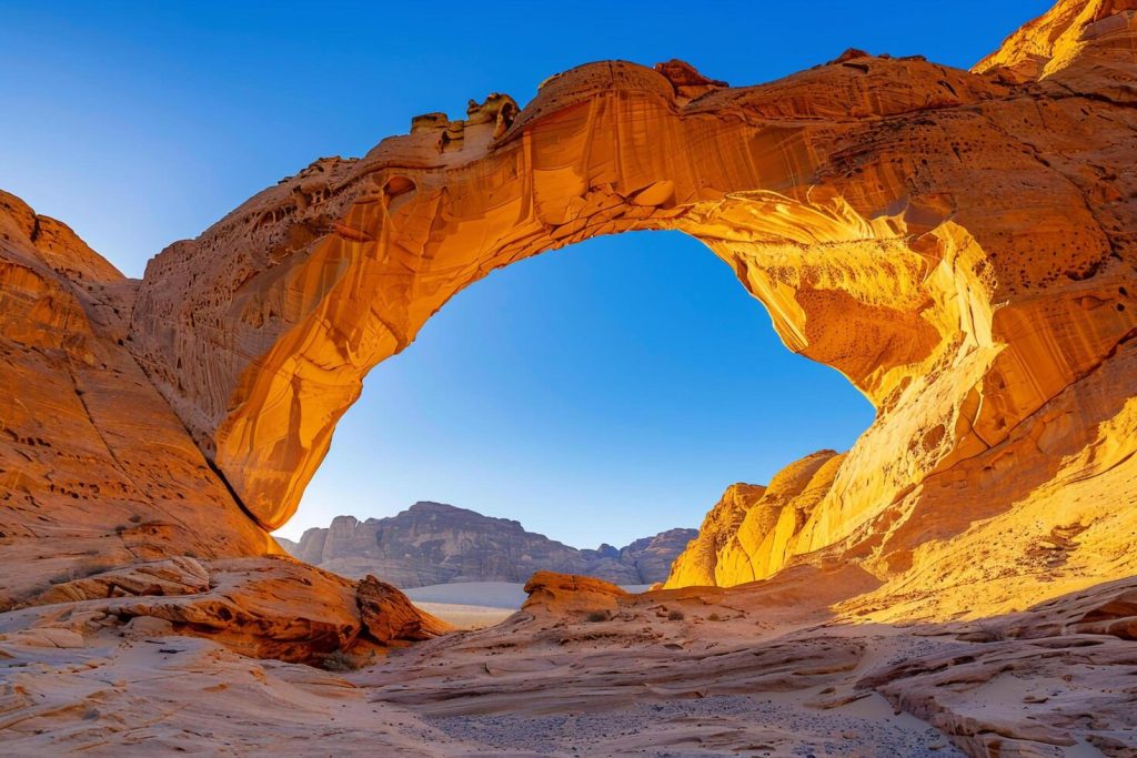
To define Wadi Rum, Jordan,n is to acknowledge a territory that functions as both a “Protected Area” and a “Living Cultural Landscape.” Spanning 720 square kilometres, the Wadi Rum Protected Area is a UNESCO World Heritage site recognised for its “Outstanding Universal Value.” It is not a singular valley but a network of corridors, inselbergs, and desert basins that have served as a crossroads for trade and migration since the Neolithic era.
Multi-Perspective Explanation
From a Geological Perspective, the region is a showcase of the “Red Sea Rift” dynamics. The basement rocks consist of Precambrian granite and gneiss, over which massive layers of Cambrian and Ordovician sandstone were deposited. The characteristic red hue is a result of iron oxide staining, while the verticality of the cliffs is maintained by a process called “Sapping,” where groundwater weakens the base of the sandstone, causing large blocks to collapse. Archaeologically, the area is a vast open-air library, containing over 25,000 petroglyphs and inscriptions that document the evolution of the Arabic language and the early domestication of camels. From a Sociological Perspective, the landscape is managed by the Zalabia and Sweilhieen tribes, whose integration into the “Tourism Economy” represents a modern adaptation of nomadic survivalism.
Oversimplification Risks
The primary risk in analysing this region is “Cinematic Reductionism”—the tendency to view the landscape through the lens of high-profile film productions. This oversimplification masks the “Bio-Crust Integrity” of the desert, where micro-ecosystems of lichen and moss stabilise the sand and fix nitrogen. Furthermore, the “Homogenization of the Bedouin” ignores the internal complexities of tribal governance and the tension between traditional nomadic rights and the “Regulatory Constraints” of a modern protected area. A failure to recognise these layers leads to a surface-level engagement that misses the systemic vulnerability of the desert’s hydrological and cultural assets.
Contextual Background: The Evolution of the Desert Massif
The evolution of the southern Jordanian desert is a chronicle of “Pluvial and Interpluvial Cycles.” During the humid periods of the Pleistocene, the region was likely a savannah-like environment, supporting large mammals and early human hunters. As the Levant underwent progressive aridification, the inhabitants were forced to innovate, leading to the sophisticated “Water-Harvesting Systems” of the Thamudic and Nabataean civilisations.
Historically, the Wadi served as a critical link on the “Incense Route,” connecting the Arabian Peninsula with the Mediterranean. The 20th century introduced a new layer of significance during the Arab Revolt, where the desert’s topography dictated the “Guerrilla Tactics” of T.E. Lawrence and the Hashemite forces. Today, the transition from a “Conflict Zone” to a “Global Heritage Asset” marks the defining systemic shift of the region. This evolution is managed by the Aqaba Special Economic Zone Authority (ASEZA), which oversees the delicate balance between high-volume visitation and “Environmental Stewardship.”
Conceptual Frameworks for Arid Landscape Analysis
Professional geographers and conservationists utilise specific mental models to audit the viability and significance of the southern desert.
1. The “Island Biogeography” Model
In the desert, the sandstone massifs (Jebels) act like “Islands” of biodiversity surrounded by a “Sea” of sand. Each massif has unique microclimates—shaded canyons (siqs) and high-altitude springs—that support isolated populations of flora and fauna, such as the Sinai Rosefinch or the Ibex.
2. The “Carrying Capacity” Framework
This model assesses the maximum number of visitors the ecosystem can support without permanent degradation of the “Paleo-Surface.” In the Wadi, this involves calculating the impact of 4×4 vehicle tracks on the fragile desert pavement and the strain on the limited groundwater resources used by permanent camps.
3. The “Intangible Heritage” Logic
This framework posits that the desert is not just a physical space but a “Repository of Memory.” The traditional knowledge of tracking (athr), botanical medicine, and navigational astronomy is considered critical to the region’s integrity, as are the rock formations themselves.
Key Categories of Terrain and Cultural Variation
Navigating the Wadi Rum landscape requires matching the “Interventional Objective” to the specific topographical or cultural category.
| Category | Primary Feature | Significant Constraint | Ideal Use Case |
| Sandstone Inselsbergs | Jebel Rum; Jebel Khazali. | Technical climbing difficulty. | Mountaineering; Geomorphology. |
| Playa (Mudflats) | Disah Basins. | Subject to flash flooding. | Archaeological survey; Hydrology. |
| Cultural Corridors | Lawrence’s Spring; Siq Barrah. | High “Visitor Density” risks. | Petrography; Historical analysis. |
| The “Red Sands” | Al-Hasany Dunes. | Fragile bio-crusts. | Aesthetic study; Wind dynamics. |
| Aquifer Zones | Rum Village Wells. | Depletion risks. | Resource management; Sociology. |
Detailed Real-World Scenarios and Logistical Logic
static.vecteezy.com
The “High-Resolution” Archaeological Mapping
A research team seeks to document newly discovered Thamudic inscriptions in a remote northern canyon.
-
Decision Logic: Selection of “Camel-Based Transport” over motorised 4×4 vehicles.
-
Analysis: Motorised access creates irreversible “Tire Scarring” in narrow siqs and disrupts the acoustics of the valley. Camels provide “Low-Impact Mobility” and access to terrain where sand depth traps vehicles.
-
Outcome: The team preserves the site’s integrity while maintaining the “Acoustic Silence” necessary for ethnographic recording.
The “Extreme Heat” Medical Extraction
A hiker experiences heat exhaustion in the “Seven Pillars of Wisdom” area during a shoulder-season temperature spike.
-
Decision Point: Ground vehicle vs. Aerial extraction.
-
Outcome: The team chooses Ground Vehicle with Bedouin Navigators. While aerial extraction seems faster, the “Turbulence Patterns” near vertical cliffs and the lack of landing pads make it high-risk. Local Bedouins utilise “Canyon Shadows” and knowledge of “Sub-Surface Moisture” to stabilise the patient during a rapid ground exit.
Planning, Cost, and Resource Dynamics
The “Economic Architecture” of a desert expedition is dictated by the “Logistical Tail”—the cost of transporting water, fuel, and specialised guides into the deep interior.
Wadi Rum Resource Tiers (2026 Estimates)
| Tier Level | Daily Cost (USD) | Infrastructure Grade | Primary Support |
| Deep Wilderness | $300 – $500 | Mobile bivouac; No tech. | Senior Bedouin Trackers. |
| Eco-Sancutary | $150 – $250 | Solar power; Water recycling. | Certified Wilderness Guides. |
| Standard Heritage | $70 – $120 | Permanent camp; Shared bins. | Community-based guides. |
| Village Peripheral | $30 – $60 | Guesthouses; Grid power. | Local family operators. |
Tools, Strategies, and Support Systems
A rigorous desert strategy requires a “Redundant Stack” of equipment and survival logic:
-
High-Offset Differential 4x4s: Standard SUVs are insufficient; vehicles must be modified for “Flotation” on soft sand and “Heat Dissipation” for the cooling systems.
-
Thermal Inertia Management: Utilising the “Diurnal Temperature Swing”—sandstone holds heat at night and stays cool in the morning.
-
Off-Grid Water Purification: Relying on the village well is a single point of failure; portable UV and mechanical filtration are mandatory for deep explorations.
-
Offline Navigational Arrays: GPS can be unreliable in narrow canyons (“Multi-pathing”); topographic maps based on French IGN surveys remain the fallback.
-
Traditional Shade Engineering: Utilising “Beit al-Sha’ar” (goat hair) principles—the material expands when wet to block rain and shrinks when dry to allow airflow.
-
Radio-Frequency Comms: Relying on cellular “Shadow Zones” is a risk; UHF/VHF radios are the standard for inter-vehicle communication.
Risk Landscape and Failure Modes
The “Taxonomy of Desert Risk” includes:
-
The “Flash Flood” Compounder: Rain 50 kilometres away can cause a wall of water to rush through a dry wadi without warning.
-
The “Thermal Exhaustion” Curve: Dehydration is non-linear; once the “Core Temperature” crosses a threshold, cognitive failure leads to navigational errors.
-
The “Mechanical Sand-Ingestion” Failure: Fine silica can destroy air filters and gaskets, leading to “Vehicle Abandonment” in high-risk zones.
-
The “Petroglyph Vandalism” Risk: Irreversible damage caused by “Chalking” or touching ancient inscriptions, which introduces skin oils that accelerate erosion.
Governance, Conservation, and Long-Term Adaptation
The governance of the southern desert is a “Tri-Partite Model” involving the Jordanian government, international heritage bodies, and the local Bedouin cooperatives. The primary challenge in 2026 is the “Climate-Induced Aridification,” which is lowering the water table and stressing the endemic flora.
Adaptive governance requires “Zonal Management.” Certain areas are designated as “Wilderness Zones” where all motorised vehicles are banned, while others are “Intensive Use Zones” for high-volume tourism. A long-term adaptation checklist includes:
-
Is the “Groundwater Extraction” being monitored via satellite?
-
Does the “Ranger Patrol” have the authority to enforce “Stay-on-Track” rules?
-
Is the “Profit-Sharing” model equitable for tribes living outside the village centre?
Measurement, Tracking, and Evaluation
How do you measure the “Integrity” of a desert intervention?
-
Leading Indicators: “Bio-Crust Recovery” rates in closed tracks; “Particulate Matter” levels in the air during peak season.
-
Qualitative Signals: The “Persistence of Traditional Dialects” among younger guides; the “Successive Generation” of Ibex sightings in protected zones.
-
Documentation Examples: The “Site Condition Report” is a baseline photo-log used to track the “Weathering Rate” of inscriptions over a five-year cycle.
Common Misconceptions and Oversimplifications
-
“The Desert is Empty”: False. It is a “High-Density Cultural Site” with thousands of years of human occupancy.
-
“Red Sand is the Only Terrain”: False. The landscape includes white sand, black basalt, yellow limestone, and grey mudflats.
-
“It is Only Hot”: False. Winter nights can drop below freezing, and “Hypothermia” is a genuine risk for the unprepared.
-
“The Bedouin are Nomadic”: False. Most are now “Sedentarised” in Rum Village or Disah, practising a “Transhumant” lifestyle only seasonally.
-
“4×4 Driving is Easy”: False. “Sand-Reading” is a complex skill; the wrong tyre pressure can result in an overnight stranding.
-
“It’s a One-Day Trip”: False. To understand the “Temporal Shift” of the desert, a minimum 72-hour immersion is required.
Conclusion
The desert of Wadi Rum, Jordana,n represents a final frontier of “Systemic Adaptation.” To engage with this landscape is to enter a contract with “Deep Time,” where the geomorphology of the Earth and the history of human survival are written on every cliff face. By approaching the region with an analytical mind,d valuing conservation over consumption and nuance over spectacle, le the investigator ensures that the Wadi remains a “Functional Heritage Asset.” Success in 2026 is found in the “Resilience” of the desert’s biological and cultural systems, ensuring that the “Valley of the Moon” continues to serve as a definitive reference for human endurance.