dirganews.com – Adventure travel is often associated with mountains, jungles, or remote islands. Yet some of the most compelling journeys unfold in places where history and landscape intersect. Chittorgarh Fort is one such destination, less about adrenaline in the conventional sense and more about immersive exploration across terrain shaped by centuries of conflict, resilience, and adaptation.
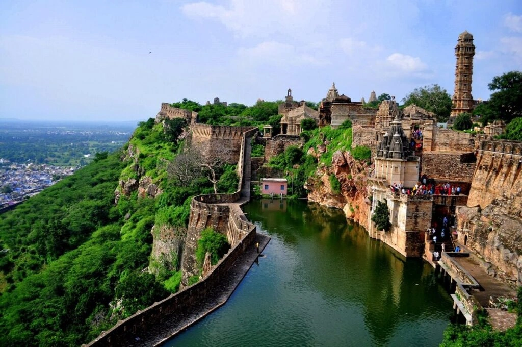
Perched high above the plains of Rajasthan, this sprawling hill fort challenges the typical definition of a historical site. It is not a single structure but a vast complex of gates, palaces, reservoirs, temples, and towers connected by winding pathways and steep ascents. Movement here is not passive sightseeing; it involves navigation, endurance, and interpretation of space.
The experience of exploring Chittorgarh Fort as an adventure destination lies in its scale and complexity. Distances are longer than expected, elevation changes are constant, and the layout resists linear exploration. Each section reveals a different layer of architectural, historical, and environmental, making it closer to a terrain-based journey than a guided walk.
This article approaches Chittorgarh Fort as a niche travel adventure. It examines not only what to see, but how to experience it as an active, exploratory environment, one that rewards curiosity, preparation, and a willingness to move beyond conventional travel patterns.
Chittorgarh Fort as an Adventure Destination
www.tour-edition.de
At first glance, Chittorgarh Fort may appear to be a historical monument suited for guided tours. In reality, its scale transforms it into a landscape that demands active engagement.
The fort stretches across roughly 700 acres, with multiple entry gates and internal zones that are not tightly clustered. This spatial distribution creates an experience closer to trekking than casual walking. Visitors who approach it passively often miss large portions of the site.
Key characteristics that define it as an adventure destination include:
- Elevation Gain: The ascent to the fort involves a winding uphill route
- Distributed Landmarks: Key sites are spread across significant distances
- Variable Terrain: Stone paths, open plateaus, and uneven ruins
- Limited Signage in Some Areas: Encouraging exploration rather than strict routes
Adventure here is not about speed or risk-taking, but about navigating a historical landscape with intention.
Historical Context and Landscape Evolution
The fort was once the capital of the region of Mewar and played a central role in medieval Indian history. Its elevated position was not accidental—it was designed for defense, visibility, and control over surrounding areas.
Rulers such as Rana Kumbha expanded the fort, adding structures like the iconic Vijay Stambh. The site also witnessed sieges by powerful figures, including Alauddin Khilji and Akbar.
Over time, the fort transitioned from a strategic stronghold to a historical monument. However, its physical layout remains largely intact, preserving the spatial logic of defense and survival. This makes exploration inherently dynamic; each path reflects decisions made centuries ago.
Adventure Zones Within the Fort
1. The Ascending Gates Route
The approach to the fort passes through multiple gates, each positioned strategically along the climb. This route offers a gradual introduction to the scale of the site.
2. Vijay Stambh Zone
The Vijay Stambh stands as a vertical focal point. Climbing the tower provides panoramic views but requires navigating narrow staircases.
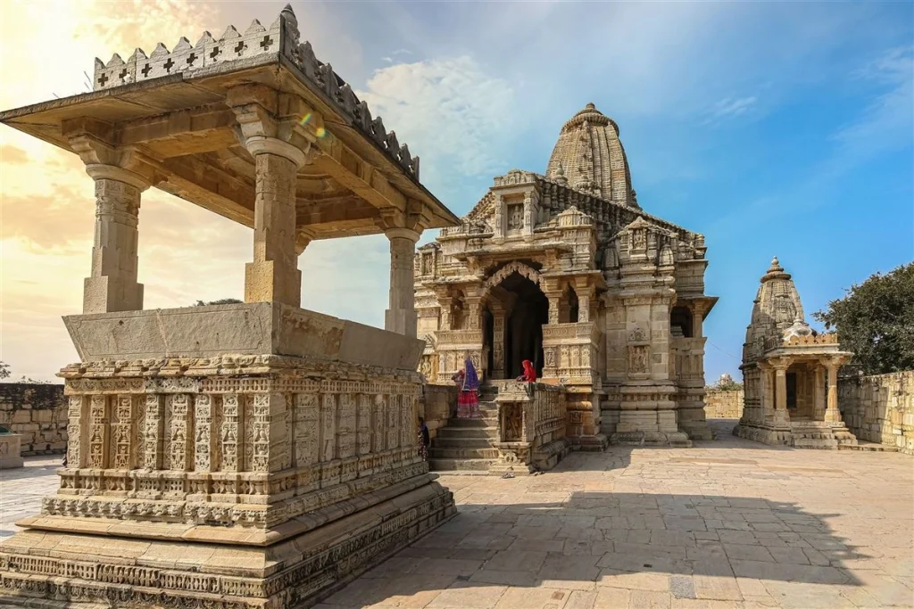
3. Rana Kumbha Palace Complex
Ruins spread across a wide area, with corridors and open courtyards that invite exploration.
4. Padmini Palace Area
Associated with Rani Padmini, this zone offers a mix of historical narrative and scenic surroundings.
5. Water Reservoir Network
Ancient water systems scattered across the fort highlight how sustainability was integrated into design.
Exploration Routes and Movement Strategies
Exploring the fort effectively requires planning movement rather than wandering randomly.
Suggested Approaches
- Loop Strategy: Start at the main gate, move through key landmarks, and return via a different path
- Zone-Based Exploration: Divide the fort into sections and explore one at a time
- Elevation Priority: Visit higher vantage points early to understand the layout
Each strategy has trade-offs between efficiency and depth of experience.
Real-World Adventure Scenarios
Adventure inside Chittorgarh Fort is not defined by a single route or experience. It emerges from how visitors interact with space, time, and physical effort. The fort’s scale creates conditions where decisions on when to move, where to go, and how long to stay shape outcomes in ways that are often underestimated.
The following scenarios illustrate how exploration unfolds in practice. Each one reflects different priorities, constraints, and potential outcomes.
Full-Circuit Exploration in a Single Day
Attempting to cover the entire fort within one day is a common approach, especially for travelers with limited time. The idea is straightforward: enter early, move continuously, and exit after completing a loop.
In reality, this scenario introduces cumulative fatigue. The distances between key points such as the ascent gates, the Vijay Stambh, and the palace complexes are longer than expected. Walking surfaces vary, and heat exposure increases as the day progresses.
Constraints:
- Time limitation
- Physical endurance
- Uneven terrain
Decision Points:
- Whether to prioritize coverage or depth
- When to rest versus continue
- Which sections to skip if time runs short
Failure Mode:
Overextending early in the day without pacing.
Second-Order Effect:
Reduced engagement with later sections, leading to rushed or incomplete exploration.
Sunrise-to-Midday Immersion
Entering the fort at sunrise offers a different dynamic. Light conditions gradually reveal the landscape, and temperatures remain relatively manageable during the early hours.
This scenario emphasizes atmosphere and observation rather than speed. Movement is slower, but perception is sharper.
Constraints:
- Limited initial visibility
- Short optimal time window before heat increases
Decision Points:
- Choosing vantage points for early exploration
- Balancing photography with movement
- Deciding when to exit before conditions shift
Failure Mode:
Spending too much time in one area early on.
Second-Order Effect:
Missing broader sections of the fort due to reduced time later.
Independent Exploration Without Structured Route
Some visitors choose to explore without a predefined path, allowing curiosity to guide movement. This approach can lead to unexpected discoveries, less-visited ruins, quiet corners, and alternative viewpoints.
However, the fort’s size introduces navigational ambiguity. Without a mental map, movement can become inefficient.
Constraints:
- Lack of clear directional structure
- Risk of revisiting the same areas
Decision Points:
- When to continue exploring versus reorient
- How to identify landmarks for reference
- Whether to seek external guidance
Failure Mode:
Disorientation leading to inefficient movement patterns.
Second-Order Effect:
Energy depletion without proportional coverage of key sites.
Vertical Exploration Focus
Focusing on vertical structures, such as towers and elevators,d creates a different type of challenge. Climbing narrow staircases and navigating changes introduces physical intensity within a smaller area.
The interior of structures like Vijay Stambh requires careful movement, as passages are tight and lighting is limited.
Constraints:
- Confined spaces
- Steep, repetitive climbing
- Limited airflow
Decision Points:
- Whether to climb during peak heat or cooler hours
- Managing energy between climbs
- Deciding how many structures to include
Failure Mode:
Underestimating the physical strain of repeated ascents.
Second-Order Effect:
Reduced capacity for broader exploration afterward.
Planning, Costs, and Logistics
Cost Overview
| Category |
Estimated Range |
Notes |
| Entry Fee |
Low |
Affordable for most travelers |
| Transport |
Moderate |
Depends on distance |
| Guide Services |
Optional |
Adds depth, but not required |
| Food & Supplies |
Low–Moderate |
Limited options inside |
Key Considerations
- Allocate sufficient time (4–8 hours minimum)
- Carry water due to extended walking distances
- Plan entry and exit points
Tools and Travel Strategies
Exploring Chittorgarh Fort as an adventure landscape is less about specialized gear and more about how tools are selected, combined, and used within a structured approach. The environment is not extreme in the conventional sense, but its scale, exposure, and terrain create cumulative strain. Tools, therefore, function primarily as enablers of consistency, helping maintain energy, orientation, and awareness over time.
What matters is not the quantity of equipment, but the coherence between tools and movement strategy.
Navigation Tools: Maintaining Spatial Awareness
Unlike compact historical sites, Chittorgarh Fort requires active navigation. Paths are not always linear, and landmarks are distributed across a wide area.
Core Tools:
- Offline maps or GPS-enabled apps
- Printed layout maps (where available)
- Visual reference points such as towers and gates
Strategy:
Use a layered navigation approach to combine digital tools with visual orientation. Begin by identifying key anchor points like the Vijay Stambh and major gates, then move outward in structured segments.
Limitations:
- Digital maps may lack detailed internal pathways
- Overreliance on devices can reduce situational awareness
Navigation works best when treated as an ongoing process rather than a one-time decision.
Hydration and Energy Management: Sustaining Movement
The fort’s open layout and Rajasthan’s climate introduce gradual but persistent energy loss. Dehydration and fatigue do not occur suddenly—they accumulate.
Core Tools:
- Reusable water bottles or hydration packs
- Light, energy-dense snacks
- Electrolyte supplements (optional)
Strategy:
Adopt a steady intake pattern rather than reactive consumption. Small, regular hydration reduces fatigue and maintains clarity.
Limitations:
- Carrying too much increases the load
- Insufficient supply limits exploration range
Energy management is less about endurance and more about pacing.
Footwear and Mobility: Adapting to Terrain
The terrain within the fort varies—stone pathways, uneven surfaces, and worn steps. Movement requires stability rather than speed.
Core Tools:
- Comfortable walking shoes with grip
- Lightweight clothing for mobility
Strategy:
Prioritize stability over minimalism. Footwear should support long-distance walking and minor elevation changes.
Limitations:
- Inappropriate footwear increases fatigue and risk of slips
- Overly heavy gear reduces agility
Mobility tools directly influence how much of the fort can be explored effectively.
Sun Protection Systems: Managing Exposure
The fort offers limited shade in many areas. Exposure to sunlight becomes a defining factor, particularly during midday.
Core Tools:
- Hat or cap
- Sunglasses
- Sunscreen
Strategy:
Plan movement around exposure cycles—explore open areas early or late, and use shaded zones for rest.
Limitations:
- Protection reduces discomfort but does not eliminate heat stress
- Overexposure still affects energy levels
Sun management is a strategic concern, not just a comfort issue.
Documentation Tools: Capturing and Structuring Experience
Photography and note-taking are often treated as secondary activities, but they can serve as tools for engagement and orientation.
Core Tools:
- Camera or smartphone
- Notebook or digital notes
Strategy:
Use documentation selectively. Capturing key points helps create mental anchors and reinforces spatial understanding.
Limitations:
- Excessive focus on documentation disrupts flow
- Equipment requires handling and care
Documentation is most effective when integrated into movement, not separated from it.
Time Management Tools: Structuring Exploration
Time is one of the most underestimated constraints. Without structure, exploration becomes fragmented.
Core Tools:
- Watch or time-tracking app
- Predefined time blocks for zones
Strategy:
Divide the fort into segments and allocate an approximate time to each. This prevents overinvestment in one area at the expense of others.
Limitations:
- Over-structuring reduces flexibility
- Under-structuring leads to incomplete coverage
Time management is a balancing act between discipline and adaptability.
Lightweight Carry Systems: Balancing Load and Utility
Everything carried affects movement efficiency. Weight accumulates quickly, especially over long distances.
Core Tools:
- Small backpack
- Organized compartments for essentials
Strategy:
Carry only what supports immediate needs. Redundancy should be minimal but intentional.
Limitations:
- Overpacking reduces mobility
- Underpacking increases vulnerability to environmental factors
Load management influences both physical and cognitive performance.
Strategic Integration: Aligning Tools with Movement
Tools do not operate independently. Their effectiveness depends on how they are integrated into a coherent approach.
For example:
- Navigation tools reduce uncertainty but require energy to use effectively
- Hydration systems support endurance but add weight
- Sun protection improves comfort, but must be combined with timing strategies
The goal is not optimization of individual tools, but alignment across all elements.
Operational Insight
The presence of tools can create an illusion of preparedness. In reality, tools only extend capability—they do not replace planning or awareness.
In the context of Chittorgarh Fort, effective travel strategies emerge from:
- Consistent pacing rather than bursts of activity
- Structured exploration with room for adjustment
- Awareness of cumulative factors such as heat and fatigue
- Integration of tools into a unified system
Adventure here is not defined by difficulty alone, but by how well movement is managed over time. Tools support that process, but they do not define it.
Risk Awareness and Safety Considerations
Risks are relatively low but present:
- Slippery surfaces in certain areas
- Heat exposure during midday
- Navigational confusion in large zones
Mitigation involves pacing, awareness, and preparation.
Long-Term Preservation and Responsible Travel
Chittorgarh Fort is a UNESCO-recognized site. Preservation depends on visitor behavior.
Responsible practices include:
- Avoiding damage to structures
- Respecting restricted areas
- Minimizing environmental impact
Measuring Your Experience
Adventure in this context is subjective, but can be evaluated through:
- Coverage of key zones
- Depth of exploration
- Physical engagement with terrain
- Understanding of historical layout
Common Misconceptions
- It is a quick sightseeing stop
- All attractions are close together
- Guides are mandatory
- The fort is flat and easy to navigate
- It lacks adventure value
- One visit is sufficient to see everything
Ethical and Cultural Considerations
The fort represents significant cultural heritage. Visitors should approach it with respect for its history and symbolism.
Conclusion
Chittorgarh Fort offers a form of adventure that is often overlooked, one rooted in exploration, interpretation, and movement through a historically layered landscape. It challenges assumptions about what constitutes adventure travel by shifting focus from thrill to engagement. For those willing to approach it actively rather than passively, the fort reveals itself not just as a monument, but as a terrain shaped by centuries of human decision-making.