Understanding Tràng An, Vietnam
Deep Contextual Background and Geological Evolution
Conceptual Frameworks and Spatial Models
1. The Karst Hydrological Drainage Matrix
2. The Stratigraphic Archaeological Succession Model
3. The Ecotourism Carrying Capacity Threshold
Key Categories and Variations of Exploration Routes
-
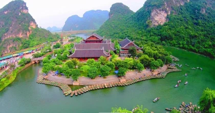
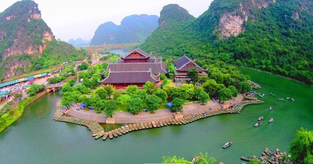
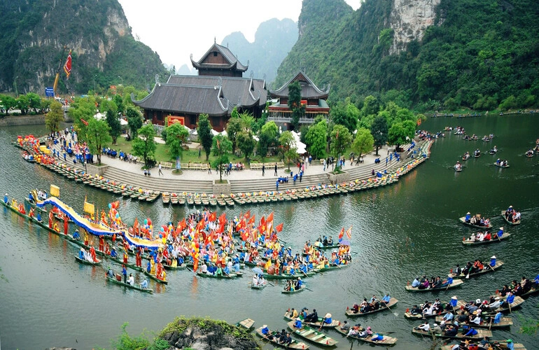
Route 1 (The Temple and Cave Circuit): A comprehensive water-borne journey taking sampans through nine major subterranean water caves and past historic temples such as Trình and Trần. Trade-off: Maximum archaeological and geological depth balanced by longer duration and higher visitor density.
-
Route 2 (The Movie Set and Valley Circuit): A visually striking route featuring passage through fewer caves but incorporating the recreated Skull Island film set and expansive valley crossings. Trade-off: High scenic photography value balanced by shorter subterranean exploration.
-
Route 3 (The Spiritual and Pagoda Circuit): A specialized pilgrimage route connecting deep valley networks to ancient mountain pagodas, requiring extended physical walking. Trade-off: Deep spiritual immersion and remote scenery balanced by high physical exertion demands.
-
Independent Bicycle Perimeter Touring: Exploring the agricultural roads, rice paddies, and peripheral limestone foothills surrounding the core UNESCO zone via bicycle. Trade-off: Absolute schedule freedom and zero boat fees balanced by exclusion from the interior water cave networks.
-
Elevated Mountain Viewpoint Ascents: Climbing the steep stone staircases of surrounding peaks, such as Hang Múa, to gain panoramic aerial vistas of the entire Tràng An valley complex. Trade-off: Unmatched photographic perspectives balanced by intense physical climbing demands.
-
Private Local Rowing Charters: Hiring licensed local rowing cooperatives for customized departure times outside peak morning tour bus hours. Trade-off: Reduced crowd exposure balanced by strict adherence to local cooperative queue rules.
Comparison of Tràng An Exploration Routes
| Exploration Route | Average Duration | Primary Cultural / Natural Focus | Notable Limitation or Constraint |
| Route 1 (Cave & Temple) | 3.0 – 3.5 hours | Nine water caves; historic Trần Dynasty temples | Extended time seated in small sampan boats |
| Route 2 (Valley & Film Set) | 2.5 – 3.0 hours | Movie sets, valley vistas, fewer water caves | High popularity during peak midday tour hours |
| Route 3 (Spiritual Circuit) | 3.0 – 3.5 hours | Remote mountain pagodas and deep valleys | Requires significant physical walking stamina |
| Perimeter Cycling | Flexible (1–4 hours) | Agricultural villages and outer foothills | Does not enter restricted interior water network |
| Mountain Viewpoint Hiking | 1.0 – 1.5 hours | Panoramic aerial photography of karst basins | Steep, uneven stone steps; high heat exposure |
Realistic Decision Logic
Detailed Real-World Scenarios and Operational Dynamics
The Peak Morning Tour Bus Congestion
-
Failure Mode: Massive queues of tour buses discharge thousands of visitors simultaneously, resulting in a two-hour wait at the ticket counter and congested boat traffic inside the narrow cave entrances.
-
Second-Order Effect: The peaceful atmosphere of the water caves is compromised by echoing voices and boat collisions, reducing the quality of the ecological and cultural experience.
The Wet Season Water Level Restriction
-
Failure Mode: Continuous torrential rainfall raises water levels in the subterranean rivers above safe clearance limits for the low-ceiling water caves.
-
Second-Order Effect: Park management temporarily closes specific cave routes to prevent passenger head injuries, forcing visitors to pivot to land-based cultural sites in nearby Hoa Lư.
The Early Morning Rowing Success
-
Failure Mode: None; the ticket queue is minimal, and the traveler secures a private sampan with an experienced local rower.
-
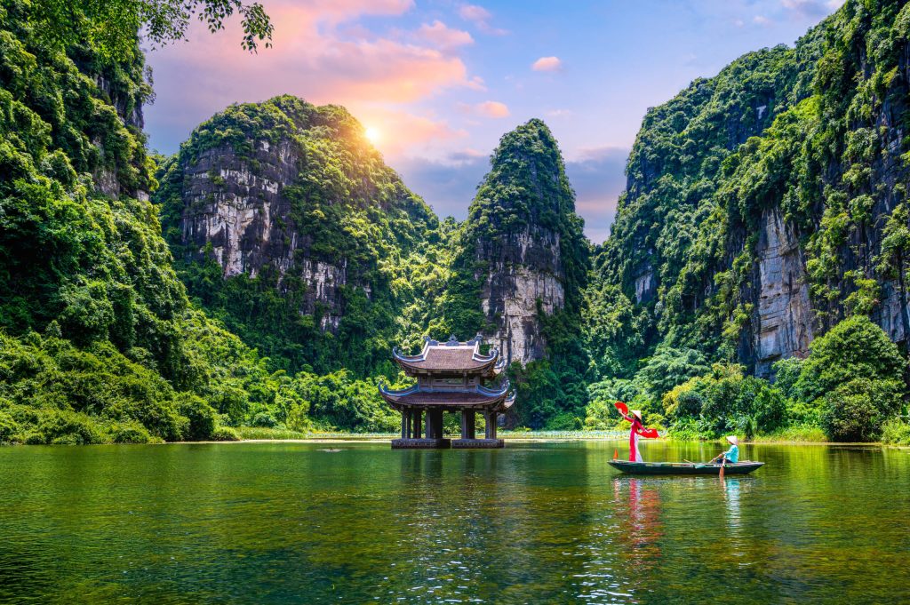
Second-Order Effect: Gliding through the misty, silent water caves in the early morning light offers an undisturbed encounter with the natural acoustic and visual majesty of the karst topography.
The Cycling and Rural Integration Strategy
-
Failure Mode: The traveler misses the interior water cave networks but engages directly with local rice farmers and water buffalo herders.
-
Second-Order Effect: The experience provides an authentic, low-impact perspective on daily rural life in the Ninh Bình countryside without encountering mass tourism infrastructure.
Planning, Cost, and Resource Allocation
Financial Dynamics and Cost Variability
| Planning Element | Estimated Cost (VND / USD Equivalent) | Primary Cost Driver | Financial Risk / Value Impact |
| Official Complex Admission & Boat Ticket | 250,000 – 300,000 VND ($10 – $12 USD) | Mandatory per-person boat charter fee | Fixed baseline cost; mandatory for water entry |
| Private Hanoi Transfer (Roundtrip) | 1,200,000 – 2,500,000 VND ($50 – $100 USD) | Vehicle size, private car vs limousine bus | High convenience for single-day itineraries |
| Local Bicycle Rental | 50,000 – 100,000 VND ($2 – $4 USD) | Daily equipment rental rates | Exceptional value for perimeter exploration |
| Viewpoint Entry Fees (e.g., Hang Múa) | 100,000 VND ($4 USD) | Private property access to mountain stairs | Minor fee for panoramic photography access |
Opportunity Costs and Resource Allocation
Tools, Strategies, and Support Systems
-
Official Park Ticketing Portals: Authorized ticket booths at the central marina managing standardized boat allocations and cooperative rowers.
-
Offline Cartographic Mapping Apps: Downloadable GPS navigation tools tracking rural bicycle paths and limestone ridge contours without cellular data.
-
Regional Meteorological Trackers: Weather monitoring software forecasting heavy rainfall events that trigger subterranean river closures.
-
Local Cooperative Rowing Rosters: Centralized administrative systems ensuring fair wage distribution and shift rotation among local oarspeople.
-
Archaeological Site Guidebooks: Academic literature detailing the prehistoric shell middens and Paleolithic habitation layers discovered within regional caves.
-
Digital Offline Translation Apps: Communication tools facilitating seamless interactions with local homestay owners, bicycle renters, and food vendors.
-
Sustainable Tourism Code Guidelines: Environmental frameworks instructing visitors on waste reduction and wildlife protection within the UNESCO buffer zone.
-
Professional Photography Timing Guides: Positional data calculating optimal morning and late-afternoon sun angles for karst landscape photography.
Risk Landscape and Failure Modes
Compounding Risks in Heritage Tourism Management
-
Monsoonal Flooding and River Swells: Rapid water level rises during tropical storms trap boats inside low-ceiling caves or halt navigation entirely.
-
Over-Tourism and Ecosystem Stress: Excessive vessel traffic churning river sediment, degrading water quality, and disturbing native aquatic flora and fauna.
-
Heatstroke and Physical Exhaustion: Underestimating high humidity and direct sun exposure during mountain staircase climbs or extended open-air boat rides.
-
Unregulated Commercialization Pressures: Unlicensed vendors and unauthorized tour brokers operating outside official cooperative safety standards.
Governance, Maintenance, and Long-Term Adaptation
Monitoring and Review Cycles
Layered Maintenance Checklist
-
Pre-Trip Planning: Verify weather forecasts and seasonal water levels; secure official tickets directly at authorized park entry gates.
-
Arrival Protocol: Confirm that sampan rowers adhere to mandatory lifejacket safety rules for all passengers.
-
Environmental Stewardship: Retain all personal waste; avoid touching fragile limestone stalactites inside dark water caves.
-
Post-Visit Reflection: Support local cooperative vendors and homestays to ensure economic benefits remain directly within the resident community.
Measurement, Tracking, and Evaluation
-
Quantitative Indicators: Zero environmental degradation citations from UNESCO monitors, stable water quality indices in the Sào Khê River, and adherence to daily visitor capacity caps.
-
Qualitative Signals: High visitor satisfaction regarding natural acoustic tranquility, authentic cultural engagement with local rowers, and preservation of rural scenic vistas.
-
Documentation Standards: Maintaining travel journals and photographic archives recording geological formations, historical temple architecture, and conservation observations.
Common Misconceptions and Oversimplifications
-
Myth: Tràng An is just another name for the nearby tourist town of Tam Cốc, and the two boat tours are identical.Correction: While both feature limestone karst scenery, Tràng An is a massive, highly regulated UNESCO World Heritage complex featuring extensive subterranean water caves and official multi-route circuits, whereas Tam Cốc is a separate river system dominated by agricultural rice fields and open-air cave passages.
-
Myth: You can easily navigate the Tràng An waterways on your own by renting a kayak or paddleboard.Correction: Independent watercraft are strictly prohibited within the core Tràng An complex to preserve fragile aquatic ecosystems and ensure passenger safety; all visitors must ride in official sampans steered by licensed local oarspeople.
-
Myth: The movie sets built for Hollywood blockbusters inside Tràng An are permanent historical structures dating back centuries.Correction: The recreated indigenous village sets are temporary cinematic installations built for film production, serving as managed tourist staging points rather than ancient archaeological ruins.
-
Myth: Visiting Tràng An requires extreme physical fitness and strenuous mountain climbing.Correction: The primary boat tours require zero physical exertion from visitors, who simply sit comfortably in a sampan while local rowers propel the vessel through flat water networks.
-
Myth: The weather in Ninh Bình is uniformly pleasant year-round, making timing irrelevant.Correction: The region experiences distinct seasonal extremes, including chilly winter mists, blazing summer heat, and autumn typhoon rains that can disrupt outdoor itineraries.
-
Myth: Local boat rowers are independent freelance operators who set their own ticket prices and tips.Correction: Rowers operate under a strict, rotational cooperative system managed by local authorities to ensure equitable income distribution and standardized safety practices.
Ethical, Practical, and Contextual Considerations
Conclusion
FAQ
What is the difference between Tràng An and Tam Cốc?
Tràng An is a massive, highly regulated UNESCO World Heritage complex featuring extensive subterranean water caves and official multi-route boat circuits managed by local cooperatives. Tam Cốc is a separate river system located nearby, famous for its open-air river passage through agricultural rice fields and three shorter caves.
Can I explore the Tràng An waterways on my own without a boat tour?
No. Independent watercraft, kayaks, and paddleboards are strictly prohibited within the core Tràng An complex to protect fragile aquatic ecosystems and ensure passenger safety. All visitors must ride in official sampan boats propelled by licensed local oarspeople.
How much physical fitness is required to visit Tràng An?
The primary boat tours require zero physical exertion; visitors simply sit comfortably in a sampan while the oarsperson handles the navigation. However, if you choose to combine the boat tour with nearby mountain viewpoints like Hang Múa, you will need to climb several hundred steep, uneven stone steps.